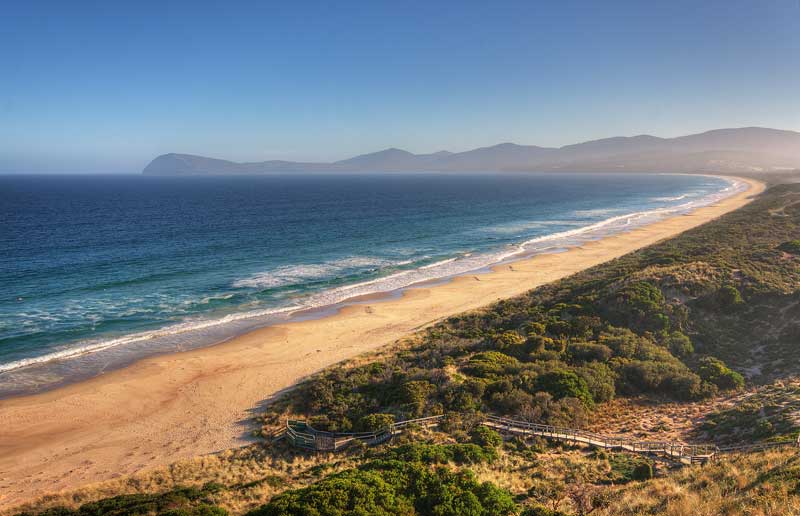
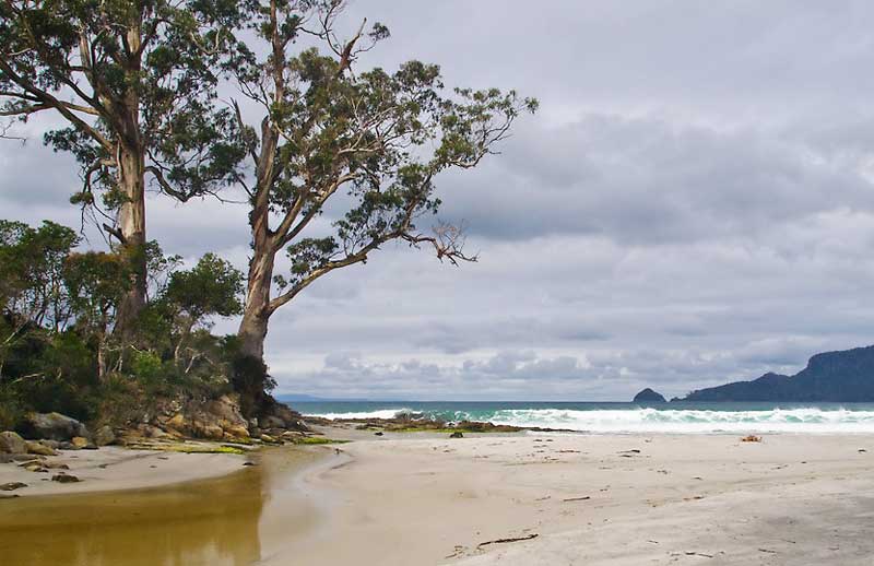
Adventure Bay, Tasmania
Adventure Bay, Tasmania
Abel Tasman
 On 2 June 1639, Dutch navigator Abel Tasman was dispatched by Antonio van Diemen, Governor-General of the Dutch East Indies, on a voyage to the north-western Pacific, in what was to be an unsuccessful search for certain 'Islands of gold and silver', east of Japan, which, as we now know, don't exist. In 1642 he set out on the first of his two 'South Land' expeditions. The expedition left Batavia on 14 August 1642 with two vessels, the Heemskerk with sixty men and the Zeehaan with fifty men on board. They first called at Mauritius, where they stayed for a month long repair to both ships.
Tasman decided to sail his ships east along the south coast beyond Cape Leeuwin. He did this and reached the islands of St Peter and St Francis on the South Australian coast, then travelled further south, sighting Tasmania on 24 November 1642. Tasman named the island after the governor of The Dutch East Indies, Antonio van Diemen. The first two mountains they sighted were named Mount Zeehan and Mount Heemskirk, after their ships. Variable weather made exploration of the eastern coast difficult. Seeking shelter in a storm, Tasman put into a cove he called Storm Bay. In actual fact, he took shelter in what is known today as Adventure Bay on Bruny Island. A later explorer, Furneaux, misread Tasman's charts and called Tasman's Storm Bay Adventure Bay and gave the name Storm Bay to a larger bay nearby.
On 1 December the storm abated, allowing the ships to anchor at Green Island and put ashore for supplies at what is now known as Blackman's Bay (3km north of Bruny Island beyond Piersons Point). On the following day Tasman intended to go ashore and claim the land for Holland, but his boat crew were prevented from landing due to heavy seas. Instead, he got the ship's carpenter, Pieter Jacobszoon, to swim ashore and tie a Dutch flag to a stake on the shore, and claim possession. This having been done without mishap, Tasman moved his ships on, following the east coast of Tasmania. When the shore fell away to the northwest (Bass Strait) and the weather was coming in directly from the north, Tasman decided to quit this island and continue east, sailing on to the south island of New Zealand.
Names recalling Tasman's visit
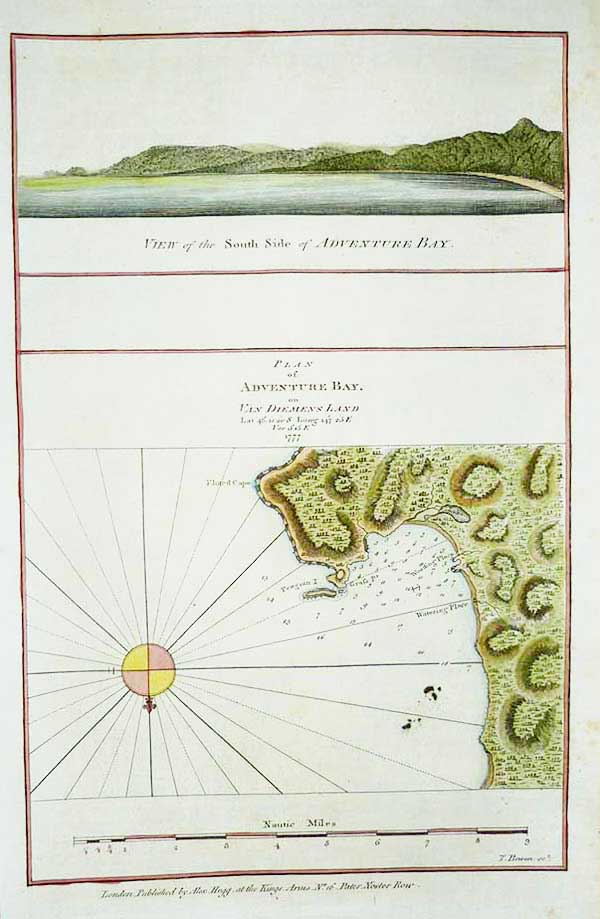
Van Diemen's Land: Anthonie Van Diemen, Governor of the Dutch East IndiesStorm Bay: storm encountered there on 29 November 1642 (the actual location was today's Encounter Bay)
Tasman Island: Abel Tasman
Frederick Henry Bay: Frederick Henrijk, a councillor of the Dutch East India Company
Boreel Head: Pieter Boreel, Councillor, Dutch East India Company.
Tobias Furneaux
 British captain Tobias Furneaux has the distinction of being the first English navigator to anchor in Tasmanian waters. Furneaux was the commander of HMS Adventure during James Cook's second voyage to the Pacific. Near Van Diemen's Land his vessel became separated from Cook in a fog. Whilst Cook sailed on to New Zealand, Furneaux travelled further north and sighted a group of islands off the South West Cape of Tasmania on 9 March 1773. James Cook was to later name the islands after Furneaux. On a four day trek following the path taken by Dutchman Abel Tasman 130 years before, Furneaux then visited a number of locations including Adventure Bay and Bruny Island, charting the coast as he went.
Others among Furneaux's crew spotted evidence of what they believed were small deer but were more likely kangaroos. Furneaux also noted signs of an Aboriginal settlement in the form of "several huts or wigwams on shore, with several bags of grass in which they carry their shellfish." - but the branches of which the huts were made were "split and torn" and there was "not the least appearance of any people."
Furneaux gave Penguin Island its name because he caught a yellow-crested penguin there. He was unable to make contact with the natives but saw signs of their existence. One of the gifts he left for them was a medal which is now held by the Tasmanian museum. Furneaux's account of his visit to Adventure Bay was published in the second Cook voyage and is on exhibit in the Bligh Museum of Pacific Exploration at Advenure Bay. Of particular interest are his favourable comments on the perfect weather at Adventure Bay.
Names recalling Furneaux's visit
Adventure Bay: HMS Adventure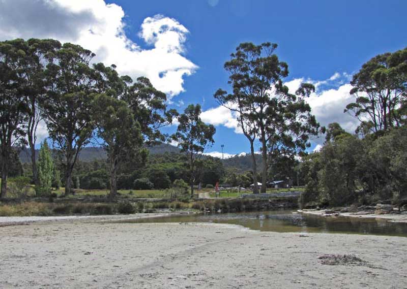
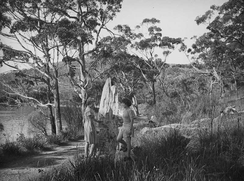
Resolution Creek, Adventure Bay, Tasmania, where Cook and others watered his ships. The location is now known as Two Tree Point
James Cook
 Of all the names that appear on the list of greats in the history of Australian exploration, none has been more glamourised than James Cook. As a result of him being given almost Godlike status by historians, governments, teachers and students, the majority of Australians actually believe Captain Cook discovered Australia. They of course are wrong, there were many explorers before him. That doesn't mean he didn't play a significant role in Australian history. His surveys and charts were the first detailed, accurate account of what the Australian continent was like, not only in the shape of its coastline, but its mountains, rivers, beaches and bays, its flora, fauna and its inhabitants to the extent it is possible to observe by exploring a ribbon of coastline. As a result of Cook's exploits, Terra Australis Incognita had become Terra Australis, no longer an unknown quantity, Cook quite put literally put Australia on the map. For this he will and should be eternally remembered.
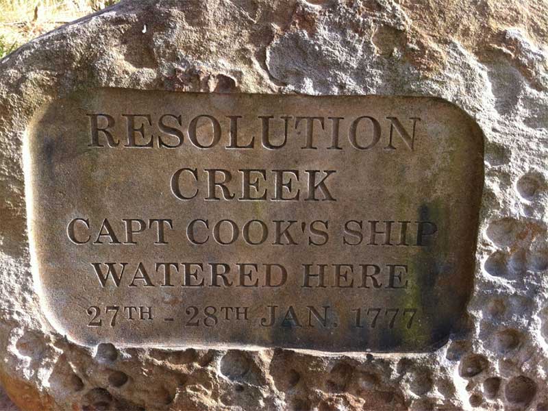
Cook did not visit Adventure Bay during his exploration of Australia's east coast in 1770, but seven years later. Four years after Furneaux's visit during James Cook's third voyage to the Pacific (1775-1780) Cook's ships - the Resolution and Discovery - anchored in the Bay, principally with a view of getting fodder for the remaining cattle. He also took on water and wood during the sojourn. Pigs were also left here, according to Cook's usual custom. According to David Samwell, surgeon's first mate on the Resolution, "both Ships anchored in Adventure Bay in Van Diemen's Land, this Bay was so called by Captn Furneaux who had anchored here in the Adventure last Voyage." There is a stone plaque marking the significance of Resolution Creek at Two Tree Point, where the crew of the Resolution collected water.
The next day Cook and Clerke sent "parties, one to cut wood and the other grass". Clerke wrote of his party from the Discovery "The Guard I had sent with the Parties on shore which consisted of the following Marines, Hamlet Thompson, Geo: Moody, Ben: Harriot, Jos: Pool & Willm Broom, stole some Liquor & made themselves exceedingly drunk, for which they receivd a dozen lashes each in the Morning." The Privates were all from the Plymouth division of marines. Hamlet Thompson was from the 6th Company, George Moody from the 70th, John Herriott the 12th, James Poole the 33rd and William Broom the 36th. According to Thomas Edgar, Master, they "made themselves so Beastly Drunk that they were put motionless in the Boat, and when brought on board were oblig'd to be hoisted into the Ship".
William Bayly, astronomer on the Discovery, wrote "In the morning I carried my Tent observatory & Instruments on Shore & set all up, but was not able to get any observations it being cloudy all day, in the evening Capt Cook Sent for me & told me he had Altered his mind relative to his stay, & ordered me to pack all up & carry the whole on board again, as he intend[ed] to sail for New Zealand in a day or two."
John Henry Martin, seaman on the Discovery, described the natives. "They have few, or no wants, & seemed perfectly Happy, if one might judge from their behaviour, for they frequently wou'd burst out, into the most immoderate fits of Laughter & when one Laughed every one followed his example Emediately."
On 29th there was "a dead Calm which continued all the day and effectually prevented our sailing… We had not be[en] long landed before about twenty of them men and boys joined us". Samwell added "The Men had not been long with us before they were joined by ten or twelve Women, some of them carrying their Children on their Baks supported by the skin of some wild beast thrown over their Shoulders & tyed before".
According to Cook "At eight o'clock in the Morning of the 30th, a light breeze springing up at West we weighed and put to sea." Edgar felt that "Adventure Bay is a very fine One & will hold a great number of Shipping. Its shelterd from all Winds that can hurt you from the Southward by Maria's Islands. In sailing into Adventure Bay with the Wind Southly be sure to give Penguin Island a small birth there being some foul ground laying off it & when Past Luff up & Steer in for the Middle of the Bay and Anchor in 12 or 13 fathm Water Sandy Bottom." After four days the ships sailed, and arrived in Queen Charlotte's Sound, New Zealand, on February 12th, 1777.
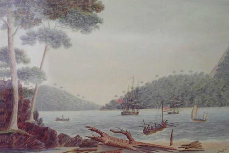
In Adventure Bay, Van Diemen's Land. Painted by Lieut. G. Tobin.
During their stay a member of the ship's crew, Lieutenant George Tobin, produced a series of watercolours of the place. One of these pictures, 'In Adventure Bay, Van Diemen's Land', shows a point with two trees on it. These trees look like younger versions of the two trees that currently stand there. It has not been established conclusively that the two trees are those painted by Tobin. However, the two existing trees and their setting on the point correspond closely with the historical imagery of this early landing site, as depicted by Tobin. This area has changed little since 1792, and is evocative of the landscape that would have been experienced by 18th century European visitors to Tasmania.
Two Tree Point today
A Bicentennial Memorial at the far end of the road around the bay at East Cove, marks the site of what is known as Cook’s Tree, a very large hardwood tree growing there when Cook anchored at Adventure Bay in 1777. The monument is a plaque on a rough-hewn rock. The 1886 log of Comte de Beavoir recorded an inscription on the tree: "Cook, 26 Jan 1777", and it was de Beavoir's log entry that led many to believe that Cook had marked the tree when he first came ashore. Some believe it was the tree to which Cook moored the boat in which he came ashore, others claim that Cook climbed the tree to view the bay across the isthmus.
Cook's journal makes no mention of marking a tree or climbing one. "On the 26th, stood off and on to find the bay, called by Tasman, Frederic Henry's Bay. On the 27th came to, and moored in 14 fathom water, in Adventure Bay, of which Cape Frederic Henry forms the North Point, and was presently joined by the Resolution. No sooner were the ships properly secured, than the pinnace was ordered to be launched, the boats to be manned, and all hands set to work in wooding, watering, cutting grass for the cattle, over-hauling the rigging, and getting every thing in readiness to con|tinue our voyage."
"Cook's Tree", 1947
Cook did not obtain his water from the so-called Cook's Rivulet at the locality of the tree as is often claimed, but at Resolution River, some 3 km to the north, whilst the tree is situated on a point still further away. Neither is there the slightest evidence in Cook's log that he ever careened his vessels in Adventure Bay — certainly not with wire ropes (the tree trunk bore wire rope marks) as these were not in use in Cook's time. The carved notation on the tree might well have been made by the French explorer, Bruni D'Entrecasteaux - it was on this point that his crew erected an observatory in 1793.
Cook obtained his wood at the small creek which enters the sea near where the mill stood at Adventure Bay, close to the present jetty. Bligh named this creek the Bounty Rivulet. Cook obtained his water from the creek further to the north, which was named Resolution River. The glamour of Cook's fame seems to have overshadowed other explorers, however, and Bounty Rivulet somehow became known as Cook's Rivulet, leading to the mistaken belief that Cook obtained water from it. Bligh named the creek after HMS Bounty, the ship he commanded when he was set adrift in the Bounty's launch by mutineers in 1789, so the naming probably took place in February 1792 during Bligh's visit to Adventure Bay at that time.
In 1930 Cook's Tree stood over three metres tall, with the carving still intact. Some time later it cut into, and the whole slab bearing the inscription was removed. It remained for many years in the possession of a Hobart merchant, but, unfortunately, was accidentally destroyed. After the slab bearing the inscription was removed a small piece of trunk that remained was removed and taken to the Bligh Museum - a small building a few hundred metres to the west - for safe keeping. The site where the tree once grew is on the same point as the freestone pillar, erected in 1977, but on the high, landward side of a tight curve in the road. In 1989 it was reported that barely the roots remained.
William Bligh
 Aboard the Resolution was William Bligh, who was later to suffer the humiliation of a mutiny aboard the Bounty during an expedition to transport breadfruit plants from Tahiti to the West Indies. Bligh visited again in 1788, bringing with him from the Cape of Good Hope a large number of fruit trees. He selected the eastern side of the bay as suitable for them because trees grew less thickly and the soil appeared to be good. At East Cove, he planted three young apple trees, nine vines, six plantain trees, orange , lemon seed, cherry, plum, peach, apricot stones, two types of Indian corn, apple and pear kernels, onions, cabbage roots and potatoes. He considered the land to be of rich, marly nature well adapted for these plants. Mr. Nelson also planted other seeds and trees around the bay. Bligh wrote that "Adventure Bay is a most convenient place for any number of ships to wood and water at but it has this inconvenience in the Winter months when southerly winds are prevalent, there is a troublesome surf on every part of the shore".
It was from here that Bligh departed on his ill fated voyage to Tahiti, and his infamous the mutiny. After the Bounty voyage and its infamous mutiny, he led another expedition to transplant breadfruit plants from Tahiti to the West Indies. Bligh set sail aboard the brig Assistant from Portsmouth in August 1791, returning to Adventure Bay on 8th February, 1792. His men sought wood at the spot chosen previously in Quiet Corner and water at Resolution Creek. He found one of the apple trees he had planted in 1788 but the rest of the garden appeared to have been destroyed by fire. The lone tree had not grown appreciably and had no fruit. Bligh then planted quinces, figs, strawberries, pomegranates, rosemary and watercress. He also turned loose a cock and two hens. One of the earliest echidna specimens was collected; Captain Bligh both drew and described this peculiar animal.
Bligh's chart of Adventure Bay
Bruni D'Entrecasteaux
 In September 1791, the French Government decided to send an expedition in search of La Perouse, a French explorer who had not been heard of since leaving Botany Bay in 1788. Bruni D'Entrecasteaux was selected to command this expedition. He was given a frigate, La Recherche (500 tons), with d'Hesmity-d'Auribeau as his second in command and de Rossel among the other officers. A similar ship, L'Esperance, was placed under Huon de Kermadec, with de Trobriand as his second in command. A distinguished hydrographical engineer, C.F. Beautemps-Beaupre, was the hydrographer to the expedition.
The expedition left Brest on 28 September 1791. The plan of the voyage was to proceed to New Holland (Australia), to sight Cape Leeuwin, then hug the shore closely all the way to Van Diemen's Land (Tasmania), inspect every possible harbour in a rowing boat, and then sail for the Friendly Islands (Tonga) via the northern cape of New Zealand. He was next to follow in La Perouse's planned tracks in the Pacific. Land was sighted in April 1792. The ships anchored in a harbour, which he named Recherche Bay, and for the next five weeks, the Frenchmen carried out careful boat explorations that revealed in detail the beautiful waterways and estuaries in the area.
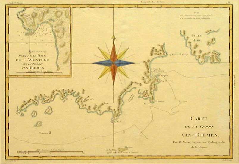
French chart of Van Diemen's Land and Adventure Bay (inset)
The party then moved on to the coast of Tasmania, charting as they went. English seafarers James Cook and William Bligh favoured the shelter of Adventure Bay, on Bruny Island, because of the opportunities there for replenishing water, wood and fish resources. The area was then assumed to form part of Tasmania’s mainland, until d’Entrecasteaux proved that it was an island. Bligh was making use of Adventure Bay’s natural facilities for HMS Providence during his second visit to Adventure Bay when the French were at Cape Town, during February 1792.
Whilst D'Entrecasteaux was attempting to find an anchorage in Adventure Bay, being himself ill in bed, the ships' navigators accidentally entered the channel to the west of Bruny Island, instead of going to the eastward of it. Thus, the discovery of the great channel named in his honour was due to an accident.
While surveying the coasts, Beautemps-Beaupre, with Lieutenant Cretin, surveyed Adventure Bay and discovered Bruny Island and the channel which separated it from the mainland. On 16th May, d'Entrecasteaux commenced to sail his ships through the channel, Port Esperance, the Huon River, and other features were discovered, named and charted, the admiral's names being given to the channel and the large island separated by it from the mainland. On 28 May 1792, the ships left Tasmania and sailed into the Pacific, continuing their search for La Perouse. The spelling of Bruni Island was changed to Bruny Island in 1918.
D'Entrecasteaux revisited Adventure Bay on 22nd February 1793, replenishing his ships' water supplies from what William Bligh would later name Bounty Rivulet (now Cook's Rivulet). During this visit to the area, the expedition explored Norfolk Bay, Frederick Henry Bay, the River Derwent, completed surveys of the Channel and visited Adventure Bay. They took on further supplies of wood, water and set up an observatory near Capt. Cook's Tree on Adventure Bay, before setting sail on 27th February.
Names recalling d'Entrecasteaux's visit
Huon River, Port Huon, Houn Point, Huonville: Huon Kermadec, commander of the EsperanceBruny Island, D'Entrecasteaux Channel: Bruni D'Entrecasteaux
Recherche Bay: frigate La Recherche
Cape Delasorte: It is generally believed it is wrongly placed on the charts of to-day. The evidence is clear that the French commander gave the name to the eastern point (now charted as Point Kelly), and not to the point on the river side of the Island. The name means 'of the same kind'. Port Cygnet: swans and cygnets seen there
Cape Direction: bearings were taken here
Betsey Island: previously named Willaunez Island after one of his officers.
Partridge Isld: named Ile Aux Perdix after crew member Jean Perdix, L'Esperance.
The Neck: named St Aignon Isthmus after a member of his expedition who waded ashore near here naked after the accidental beaching of his boat.
Tasman Head: named Point La Billiardiere after Jeane de La Billiardiere, who also sailed with Baudin, 1801-03.
Cape Bruny: named after expedition leader, Bruni D'Entrecasteaux. Originally spelt Bruni, the name was later changed to Cape Bruny.
Cape Deslacs: Hippolyte Deslacs, seaman of Recherche
The Bligh Museum of Pacific Exploration
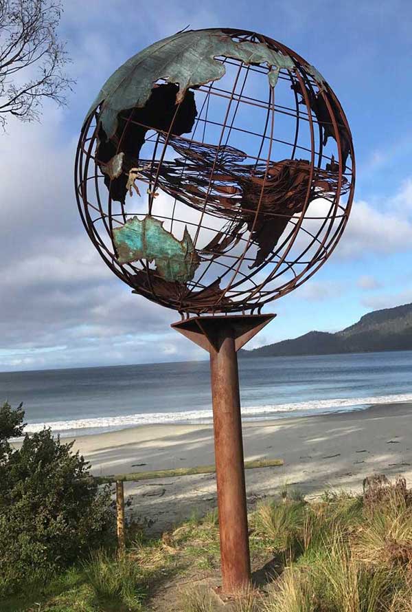
The lyrical 'Whale Pod' sculpture at Adventure Bay is a three dimensional globe of the world. Inside the globe is placed a sculpture within a sculpture - look closely and you will see floating within the globe a whale with her calf. Whale pods regularly visit Adventure Bay. A significant backdrop to this sculpture is Penguin Island which was home to one of Tasmania's shore based whaling stations during the 1820's and 1830's. This Bruny Island landmark is an initiative of the Bruny Island Art Adventure society. The work was conceived by the local community and created by well known Tasmanian sculptor Matt Carney.
Post colonial Adventure Bay
On 20 May 1802, the Geographe, one of two ships of a French expedition led by Nicolas Baudin, arrived in the area. Bad weather had prevented Baudin from entering D'Entrecasteaux Channel, so he anchored instead in Adventure Bay, taking on timber and water. Small boat voyages were made around Bruny Island and to parts of the mainland. Pierre Faure, a boat commander, discovered Eaglehawk Neck. Two days later the Geographe left Adventure Bay and followed the east coast of Tasmania, from Cape Tourville northwards, en route for Port Jackson.
Within a few years of Baudin's visit, Adventure Bay had become a centre of a whaling industry. Shore-based whaling stations operated in the bay from 1826 at four separate locations. By 1829 the Bay supported some 80 to 90 men, two sloops and up to twenty whale boats. A walk from East Cove to Grass Point will take you past numerous sites of interest - at Grass Tree Point you will see the Ruins of old whalers cottages. The Agricultural and Timber industries provided further employment and even sandstone and coal mining was undertaken on South Bruny. The Melbourne GPO and Houses of Parliament were built from Sandstone mined at Ventenat Point on South Bruny.
Trugannini, one of Australia's most famous Aboriginals, was a member of the Nuenonne band and was born on Bruny Island in 1812 the daughter of the chief Mangana. A memorial to her stands at the top of the lookout on Bruny Island's Narrow Neck, overlooking Adventure Bay.
More
About HMS Adventure
The Admiralty purchased two near new Whitby-built colliers for Cook's second voyage of discovery, the Marquis of Granby, 402 tons, and the Marquis of Rockingham, 340 tons. They were comissioned under the names of Drake and Raleigh which subsequently became the Resolution and Adventure.
Sir Joseph Banks had suggested a forty-gun ship or an East India Company ship, but the Admiralty had no hesitation in following Cook's recommendations. The ships had a larger hold than the other types and more space between decks where the men were berthed. This allowed for a greater amount of fresh air and light and also less damp conditions. Cook supervised the fitting out of the ships with the help of Lord Sandwich, First Lord of the Admiralty.
The Adventure, which cost the Navy £2,103, was placed under the command of Captain Tobias Furneaux, a Devonshireman who had been Second Lieutenant under Wallis on the Dolphin. Furneaux was an excellent seaman but unfamiliar with Whitby ships. After refitting, the Adventure sailed at 335 tons with a compliment of 81 men and one civilian. The Board of Longitude sent two astronomers on the second voyage and William Bayly sailed with Furneaux. The Adventure was a smaller edition of the Resolution, a good looking ship but she did not achieve the fame of Cook's choice.
By mid-December 1772 the two ships had reached the Antarctic waters. The first crossing of the Antarctic circle occurred in January 1773. They became separated in a heavy fog when only about 75 miles from Enderby Land but did not know that land was close. By prearrangement the future rendevouz was to be Queen Charlotte Sound, New Zealand. Furneaux visited Tasman's Van Diemens Land (Tasmania) and named Adventure Bay. He concluded there was no strait between Van Diemens Land and New Holland. However, astronomer Bayly insisted that there were coastal islands and a strait. Bayly was proven correct by the ship's surgeon, George Bass who sailed through the strait which bears his name - some 20 years later.
Cook met up with Furneaux at Queen Charlotte Sound on 18 May 1773 where he found that his strict anti-scorbutic diets had not been followed. Half of Furneaux's men had contracted scurvy and one crew member subsequently died. By a quirk of fate it was the ship's Cook, Mortimer Mahoney, known as Murduck Mahoney. Passing on to Tahiti, the Adventure was nearly wrecked when swept onto some reefs. She lost three anchors before getting clear.
After discovering islands named by Tasman, the Resolution and Adventure returned to New Zealand where they once again became separated near Cook Strait in a gale. Nine of Furneaux's men were murdered by Maoris at Queen Charlotte Sound and he returned to England twelve months ahead of Cook.
Furneaux's Adventure returned to her Whitby owners and sailed on for a further 35 years. In 1811 she was in the St. Lawrence River, the scene of Cook's magnificent charting work, but Cook was not there to guide her through the treacherous reaches. The great river was determined to perpetuate the memory of Cook and claimed the Adventure for all time when she was wrecked there.
The "Providence" and "Assistant" at Anchor in Adventure Bay. Drawn by Lieut. G. Tobin, 1792.