Naming Australia's Coastal Features

Batemans Bay to Mackay
North Head
Its location.
Brush Isld
Descriptive of its vegetation.
Burrill Lake
Of Aboriginal origin, meaning a tree with a green and white leaf.
Warden Head
Recalls Ulladulla pioneer shipbuilders David and James. One of first industries was shipbuilding on the shore of Ulladulla Beach by Warden & Gee in the early 1840s. Originally named Warden's Head.
Lake Conjola
Of Aboriginal origin, presumably their name for the lake.
Wreck Bay
Many ships have been wrecked here. One of the most well known wrecks was a convict transporter named the Hive. This ship went aground on 10th December 1835 and was totally wrecked. It wasn't until the Barque Juniper went down there in September 1850 that its present name was given.
Cape St George
23 April 1770. Cook. It was discovered by Cook on St George's Day. The lighthouse built at St George's Head had to be destroyed because it was built in the wrong place, and was a danger to shipping.
St Georges Basin
Takes its name from nearby Cape St George/ Surveyor Thomas Florence recorded the Aboriginal name - Bherwerre - for the basin in 1827.
Sussex Inlet
Recorded by surveyor Thomas Florence in 1827 as Sussex Haven.
Erowal Bay
Of Aboriginal origin, presumably their name for the bay. Originally spelt Erowhal.
Bherwerre beach / peninsula
Of Aboriginal origin, presumably their name for the area.
Callala Bay
Thought to derive either from 'kallala' (meaning 'fish') or from one of Alexander Berry's convicts, Patrick Smith, who lived in the area and was born at Calala in Ireland.
Culburra Beach
Of Aboriginal origin, presumably their name for the area.
Warrain Beach
Of Aboriginal origin, presumably their name for the area.
Tilbury Cove
Recalls Tilbury, a major dockyard on the River Thames, London, England.
Hyams Beach
Hyam's Beach has the whitest sand in the world according to the Guinness Book of Records.
Bowen Isld
1791. Bowen. Lt. Richard Bowen the naval agent on board the transport ship "Atlantic" called into the bay in 1791. The ship was part of the Third Fleet. Lt. Grant of Lady Nelson surveyed Bowen Island in March 1801, naming it Ann's Island after Governor Kings' wife, but this name was never officially adopted.
Jervis Bay
1791. Bowen. Named after Sir John Jervis (later Earl of St Vincent ), Bowen's former commanding officer in the Royal Navy. The Australian Parliament selected the site of Captain's Point, Jervis Bay, for the Royal Australian Naval College (RANC) on the 7.11.1911. The college is known as HMAS Creswell.
Pt Perpendicular
Named Pt Upright by Cook, 22.4.1770, due to perpendicular cliffs. Changed to its existing name during colonial times.
Honeymoon Bay
A small heart-shaped beach on the Beecroft Peninsula, it has been a popular holiday location since the early 20th century, from which it derived its name.
Murrays Beach
Commemorates the late Cecil McLeod Murray, who established the first mechanical workshop in Sawtell.
Tapalla Pt
Aboriginal name for the location.
Beecroft Peninsula / Beecroft Head
Named Long Nose by Cook in April 1770.
Crookhaven Heads
Named after a scenic village in County Cork, Ireland, on the most southwestern tip of Ireland.
Comerong Island
Aboriginal name for the location.
Shoalhaven Heads
6.12.1797. Bass. Shoals found there which brought shelter from sea waves.
Bass Point
Named Red Point by Cook, 25.4.1770.
Sandon Point
Derived from Sandon, Hertfordshire, England, the birthplace of George Adams, who purchased Bulli Colliery in the 1890's. His cottage on Sandon Point was called Sandon Cottage"
Shell Harbour
Early records shows that Shell Harbour was formally known as 'Yerrowah'. The harbour of Peterborough was called Shell Harbour not long after white settlement began because of the great quantity of shells.
Lake Illawarra
Illawarra was the native name for the area which early explorers and settlers referred to as the "Five Islands District". Flinders wrote of his visit to the area in 1796 that "this part is called Alowrie, by the natives ....." In a letter to Surveyor General Oxley dated 16 November 1816 the Colonial Secretary described the area as being "called commonly the Five Islands, but by the Natives in their own language Illawarra near the sea coast where Five Islands are seen ....." One of the first land grants in the district was 2,200 acres to David Allan in 1817. This grant was called "Illawarra Farm". The land was sold to W C Wentworth in the early 1840's and the name was changed to the Five Islands Estate.
There are a number of differing versions of the derivation and meaning of the name Illawarra.
1. The adaptation of an aboriginal word, Elouera, Eloura, or Allowrie meaning pleasant place near the sea or high place near the sea.
2. The Australian Museum affirms that Illawarra means "high place near the sea" and was derived from the language of the Wodi Wodi Tribe which inhabited the area between Wollongong and the Shoalhaven River.
3. From the aboriginal word "Illowra" meaning "white fish eagle".
4. Wurra or Warra means mountain and Illa may be white clay, giving "white clay mountain".
5. A corruption of the aboriginal word "Eloura" meaning a pleasant place.
6. From the aboriginal word "illowra" meaning pipeclay.
7. From the aboriginal word "Dhgillawarah" meaning "keep awake at night". The story is that Five Islands Point "was a special vantage ground from which the aborigines watched day and night against the possibility of a sudden attack being made upon them by any hostile tribes ....."
Five Islands
Descriptive name. Two groups of low rocky islets, E and NE of Port Kembla, and about 5-8 km SE of the city of Wollongong. The earliest traced reference to the group as "the five islands" was made by George Bass in his journal on 5 December 1797, ....."and at sunset passed the five islands laying off Hat Hill".
1. Big Island - The largest island in the group. Formerly known as "Perkins" Island. The name Perkins (Parkyns) was from a family who lived on the Island for some years, probably between 1866 and 1870. The original Perkins (Parkyns) established a home on the Island and made a living by catching sharks and selling oil.
2. Flinders Islet and Bass Islet - The two most northerly islands, known together as Tom Thumb Islands. These Islands are named for Bass and Flinders who gave the name "the Five Islands" to the island group following an expedition in their small boat the "Tom Thumb". Flinders Islet has also been known as Wollongong or Toothbrush Island. Bass Islet has been called Pig Island. The legend is that following a heavy flood, a pig from the mainland was washed up on this island and lived there for a number of years.
3. Martin Islet - The southernmost island of the group. The Island is named after a youth called William Martin who accompanied Bass and Flinders on their journey.
4. Rocky Islet - The small island which looks like an outcrop from the larger islands. It was shown on admiralty charts as "foul ground".
Port Kembla
An aboriginal word meaning "plenty of wild fowl". Originally known as Red Point. It has also been referred to as Kembla Bay and Five Islands Bay. The earliest reference to this name seems to have been in 1892. The new harbour was named Port Kembla by a Mr Burrell who opened the Mt Kembla Colliery and constructed the tramway between the colliery and the jetty.
Semi-Detached Point
Origin unknown.
Mid Era Point
Believed to be the Aboriginal name of the location.
Thelma Head
Origin unknown.
Garie North Head / Garie Beach
First recorded as Garrah, the name of a 130 acre grant here to Andrew Byrne in 1831. There are three theories to its meaning: 1. Aboriginal word meaning: 'sleepy'; 2. Geera, Garie or Geara: not Aboriginal in origin; 3. named after a bushranger William Geary who is said to have camped here while on the run in 1818.
Curracurrong
Believed to be the Aboriginal name of the location.
Curracurrang
Similar in spelling to Curracurrong, it appears to be a variation on that name.
Wattamolla
An Aboriginal name which either means 'place near running water' or was the Aboriginal name of Wattamolla Creek which enters the ocean here. The bay was named Providential Cove by Matthew Flinders and George Bass, in March 1796 as it was here they found shelter in a violent storm.
Providential Point
Matthew Flinders and George Bass found shelter in a violent storm in nearby Wattamolla Cove in March 1796 .
Martin Head
Named after William Martin, the boy who sailed with Bass & Flinders.
Marley Beach / Head
Believed to be the Aboriginal name of the location.
The Cobblers
Origin unknown.
Jibbon Head
Also known as Port Hacking Point. Port Hacking Heads were known as Port Aiken Heads in 1870 (see Port Hacking below). Believed to be the Aboriginal name of the location. Originally recored as Deeban.
Port Hacking
29.3.1796. Bass. Named after Lieut. William Hacking, First Fleeter and first pilot of Port Jackson. Hacking was the first colonist to enter the area - on a kangaroo hunting trip.
Cape Bailly
Oct 1802, Baudin. Thought to be named after Joseph Charles Bailly, mineralogist, Naturaliste.
Botany Bay
6.5.1770. Cook. Large variety of plant specimens collected by the expedition's botanists.
Pt Sutherland
6.5.170. Cook. Named after Forby Sutherland, seaman, Endeavour, who died and was buried here.
Cape Banks
6.5.170. Cook. Named after Joseph Banks (right), botanist, Endeavour.
Cape Solander
6.5.170. Cook. Named after Daniel Carl Solander (1736-82), botanist, Endeavour.
Port Jackson
7.5.1770. Cook. Named after Sir George Jackson, Secretary for the Admiralty and Judge Advocate of the Fleet. Cook worked as a stable boy for his sister as a lad.
Blue Fish Point
Origin unknown.
Cabbage Tree Bay
Cabbage trees were once predominant here.
Fairy Bower
Originally called Montpelier Bay after the name of the subdivision - Montpelier estate - behind the bay. reddall Street was originaly called Montpelier Road and Bower Lane was called Bay Street.
North Steyne
See Manly Beach.
Manly Beach
Formerly known as South Steyne. The name 'Steyne' is taken from a thoroughfare in Brighton, England.
Queenscliff Bay
Named in honour of Queen Victoria. The name was later given to the nearby lagoon and holiday shacks.
Dee Why Head
The first recorded use of the name was in September 1815 when Surveyor James Meehan recorded in his field book, "Dy Beach - marked a honeysuckle near beach". Meehan recorded difficulty accessing the area because of the heavy brush and swamp, and it is most likely he was using an abbreviation of the Greek word "dysprositos", meaning "difficult to reach".
Long Reef / Long Reef Point
Descriptive.
Narrabeen Head / Lakes
Aboriginal name believed to mean 'fresh water'.
Turimetta Beach / Head
Believed to be a local Aboriginal clan or family name. In this area, the suffix 'etta' was part of a family names.
Warriewood Beach
In the 1880s, the Macpherson family farmed this land which was known as Warriewood. Of Aboriginal origin, its meaning is unknown.
Bongin Bongin Bay
A derivation of Bungan.
Bungan Head
The name Bungan, of Aboriginal origin, was first recorded in a survey in 1814 as Bongin Bongin, referring to an area which included present day Mona Vale and Bungan and was granted to Robert Campbell junior.
Newport Beach
The area came to be called Newport from about 1880. The name was first used in promotional literature produced for the sale of land.
Bilgola Head
Bilgola is an aboriginal name thought to mean swirling waters. James Meehan first marked as Belgoula in his survey of 1814.
Taylors Point
Recalls early settler Lieutenant James Taylor, who owned 30 acres there. He later became a well known artist.
Careel Head
Name is of Aboriginal origin, believed to be the name of an actual Aboriginal.
Dolphin Bay
The bay is named after the Dolphins which frequent the area.
Bangalley Head
Named after the bastard mahogany trees (Eucalyptus botryoides) which grow in this area.
Whale Beach
The origin of the name Whale Beach is unknown, although it is presumed to be associated either with the shape of the northern headland, or a beaching of a whale.
Little Head
Descriptive.
Barrenjoey Head
Aboriginal name meaning a young kangaroo. Has also been spelt Baranjuee, Barranyu and Barranjull.
Pitt Water
2.3.1788. Phillip. Named after William Pitt (1759-1806), Stateman and British Prime Minister.
Broken Bay
2.3.1788. Phillip. A large inlet with many bays.
Brisbane Water
Originally called North East Arm by Gov Phillip in 1789. It was renamed Brisbane Water in the early 1820s after the then-governor of NSW.
Phegans Bay, Brisbane Water
So named after John L. Phegan, - a settler. Its previous name was Burrawong Bay.
Woy Woy, Brisbane Water
Aboriginal word meaning 'big lagoon'.
Ettalong Beach, Brisbane Water
Aboriginal word meaning 'place for drinking'.
Green Point, Brisbane Water
Gov Phillip. Descriptive.
St Huberts Island, Brisbane Water
Was so named by its first owner, Father Cornelius D. Goughlan.
Rileys Island, Brisbane Water
Named after John Riley, a settler. Its previous name was Shell Island.
Pretty Beach, Brisbane Water
Descriptive.
Tallow Beach, Brisbane Water
Tallow, for soap and candle making, was made by melting the harder sections od animal fat. Like cedar, it was a valuable cargo, and it is the loss of such cargo, following a shipwreck, that gave Tallow Beach its name. The ship was The Volunteer.
Hawke Head, Brisbane Water
Also known as Box Head.
Bouddi Point, Brisbane Water
The Aboriginal namr for the area.
Avoca Beach / Lake
Named after John Moore, who had left his homeland under a cloud, received a 640-acre grant in 1830 which he called Avoca. He built a house on a ridge overlooking Avoca Lake.
Copacobana Beach
A name used in promoting a housing estate subdivision, taken from the famous beach in Rio de Janiero.
The Skillion
Its shape.
Terrigal Beach
Aboriginal word meaning 'place of little birds'. Originally spelt Tarrygal.
Wamberal Point / Lagoon
Aboriginal name for the location
Bulbaranning Bay
Aboriginal name for the location.
Forresters Beach
Named after Robert Forrester who settled there in 1861.
Bateau Bay
Bateau is French for boat. Bateau Bay lies in the area known as Darkinjung to Indigenous Australians.
The Entrance
Descriptive of its position in relation to Tuggerah Lake.
Tuggerah Isld / Tuggerah Lake
Aboriginal name for the location meaning Savannah grasslands.
Chittaway Point
Aboriginal name for the location.
Toowoon Bay
Aboriginal word for the mating call of the Wonga Pidgeon. It was adopted as the name of the property of the area's first white settler, Henry Holden. Also known as Chinamans Bay.
Norah Head
Aboriginal word norah or morah was the large stone on which adzes, knives and axes where sharpened. This was done near water - in this area. Previously known as Bungary. He was a native who accompanied Matthew Flinders on an exploration of Moreton and Harvey Bays.
Canton Beach
It was a base for Chinese fishermen in the 19th century.
Budgewoi Beach
Bongon Head
Aboriginal name for the locality.
Wybung Head
Aboriginal name for the location.
Flat Rocks Pt
Descriptive.
Munmorah Isld / Lake Munmorah
Aboriginal name for the stones used for grinding seeds.
Reid's Mistake
Named after Captain William Reid who, in 1800, became the first European to make his way into the lake. Sent from Sydney to collect coal from the mouth of the Hunter River he mistook the channel for the river estuary, ventured inside and there encountered some members of the Awabakal tribe, who directed him to some embedded in the headland. It was only upon his return to Sydney that he realised he had got the wrong coal. The lake was known as Reid's Mistake until 1826 when it was renamed in honour of Governor Lachlan Macquarie.
Lake Macquarie
10.10.1818. King. Lachlan Macquarie, Governor of New South Wales, 1810-21.
Black Ned's Bay, Lake Macquarie
Named after the last member of the Awabakal tribe to live in the area after the tribe had been destroyed. Black Ned lived there with his wife, a blind mother whom he supported, and four or five children
Pulbah Isld, Lake Macquarie
Aboriginal name meaning island. Also written Bulba. In 1870 it was said to have been known as Barryowen, possibly with the same derivation as Barrenjoey at Pittwater, to which it bears some resemblance.
Bonnells Bay, Lake Macquarie
The Bonnell family were early settlers in the area.
Coal Pt, Lake Macquarie
So named because the first coal mine on the lake was situated there.
Toronto Bay, Lake Macquarie
The name Toronto was chosen for the bay and the surrounding locality by the Excelsior Co., which owned land there, in honour of Edward Hanlan, world champion sculler who came from Toronto in Canada and who arrived in NSW at the time of the subdivision. The name was not used publicly until the Newcastle Morning Herald of 18.6.1887.
Warners Bay, Lake Macquarie
Named after Jonathan Warner, the first settler.
Cockle Bay, Lake Macquarie
Cockle shells found in abundance here.
Red Head
Descriptive.
Nobbys Head
Its shape. Previously known as Coal Island,when this feature was still an island.
Port Hunter / Hunter Bay
13.3.1788. Ball. Named after John Hunter, later Governor of New South Wales.
Newcastle Bight
The name of Newcastle was first given to a penal settlement established near the bight in 1804.
Port Stephens
11.5.170. Cook. Named after Sir Phillip Stephens, Secretary to the Admiralty.
Nelson Bay
Shown as Nelson's Bay on a map prepared by John Armstrong in 1826. Named after the survey ship Lady Nelson.
Tilligerry Peninsula
Tilligerry is the local Aboriginal word for pelican.
Lemon Tree Passage
Originally called Kooindah, a local Aboriginal name meaning 'clear water'.
Tomaree Peninsula
Aboriginal name for the peninsula.
Boondelbah Island
Aboriginal name for the island.
Broughton Isld / Head
Thought to be named after Captain Broughton who made a voyage of discovery to the North Pacific Ocean in HM Majesty's Sloop 'Providence' in the years 1795-98.
The Broadwater
descriptive.
Sugarloaf Pt
9.7.1799. Bass. Its appearance.
Myall Lakes
'Myall' is an Aboriginal word meaning 'wild'. It was apparently applied by Europeans to Aborigines who had had no contact with whites.
Cape Hawke
11.5.170. Cook. Named after Admiral Sir Edward Hawke, First Lord of the Admiralty.
Farquar Inlet
Named after Sir Robert Townsend Farquhar, Governor of Mauritius (1810-1823), who did much to abolish the Malagasy slave trade and to establish friendly relations with the rising power of the Hova sovereign of Madagascar.
Harrington Inlet
Named by John Oxley after the Earl of Harrington.
Bulladelah Beach
Derives from the language of the Worimi Aborigines who occupied the area before white settlement. It is thought to mean 'meeting place of two rivers'.
Mermaid Reef
4.12.1823. King. Named after the expedition vessel, Mermaid.
Diamond Head
Its shape.
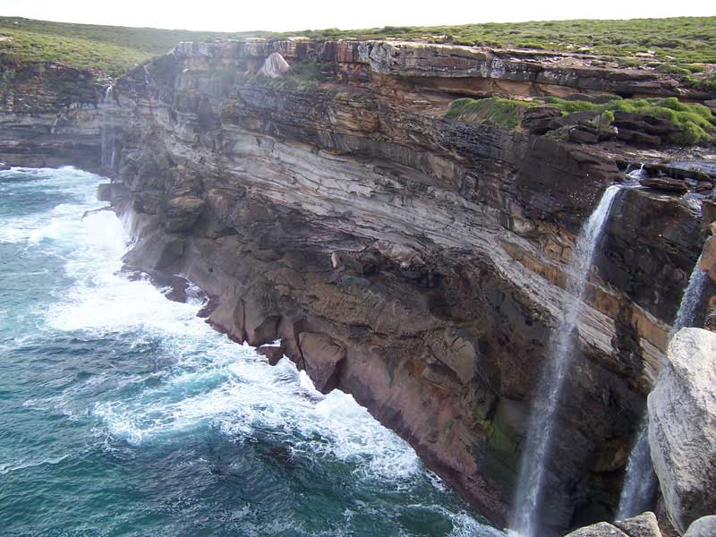
Perpendicular Pt
Descriptive of the cliffs there.
Grants Head
11.10.1818. King. Named after James Grant, explorer.
Port Macquarie
11.10.1818. King. Named after Lachlan Macquarie, Governor of New South Wales, 1810-21.
Crescent Hd
Its shape. The core of an extinct volcano which dominates the headland is called Big Nobby.
Hat Head
Its shape.
Korogoro Pt
Aboriginal name of the location.
Smoky Cape
13.5.170. Cook. Fires seen on the cape which caused much smoke.
Trial Bay
Named after the brig Trial which was wrecked there in 1816 after it had been stolen by convicts who were attempting to escape to south-east Asia.
Nambucca Hds
Name used by the Aboriginal people, the Gumbaingeri , meaning 'entrance to the waters' or 'crooked river'.
Coffs Harbour
Named Korff's Harbour by John Korff, a naval architect and shipbuilder who took shelter in the bay during a gale in 1847. The modification of the name occurred in 1861 when the town site was surveyed.
Solitary Isles - Split Solitary Isld / South Solitary Isld / SW Solitary Isld / NWSolitary Isld / North Solitary Isld
15.5.1770. Cook. Their position.
Red Rock
Descriptive.
Bare Pt / Bare Bluff
Descriptive.
One Tree Pt
Descriptive.
Sandon Bluffs
The nearby home of coal mining magnate George Adams was Sandon Cottage.
Wooded Bluff
Descriptive.
Evans Hd
August 1843. Blackwood. Named after Lieut Evans of HMS Fly.
Lennox Hd
Capt Henry Rous. Named after the 'Farmer' Duke of Lennox Line.
Broken Hd
Descriptice of its shape.
Byron Bay / Cape Byron
15.5.1770. Cook. Named after John Byron, grandfather of the poet Lord Byron, Commander of HMS Dolphin under whom Cook served.
Brunswick Hds
1828 Capt. John Henry Rous. The Brunswick River and heads at the river's mouth were named in honour of Queen Caroline of Brunswick who was the wife and consort of King George IV, the reigning monarch.
Tweed Hds
Tweed Heads takes its name from the Tweed River, which was discovered by Lieut. John Oxley and named after the River Tweed, which forms the boundary between England and Scotland.
Queensland
Burleigh Hds
1840 . James Warner . First recorded as Burly Head, meaning big or brawny, and later corrupted to Burleigh. Name possibly taken from a novel by Sir Walter Scott.
South Stradbroke Isld / North Stradbroke Isld
6.12.1823. King. Named after Sir William Hall, Viscount Dunwich, Earl of Stradbroke.
Redland Bay
Europeans named it after the soil there, but to the Aboriginal people it was Talwurrupin, the name of the wild cotton tree.
Lagoon Isld
Descriptive.
Woogoompah Isld / Woogoompah Inlet
Of Aboriginal origin.
Short Isld
Descriptive of its size.
Stringaree Isld
Of Aboriginal origin.
Kangaroo Isld
Many kangaroos seen there.
Long Isld
Its shape.
Karragarra Isld
Of Aboriginal origin.
Macleay Isld
The Island's aboriganal name is "Jencoomerha" & it was regarded as an aboriganal meeting place of spiritual importance mainly for the women of the tribes.
Garden Isld
Descriptive.
Coochiemudlo Isld
The name refers to a red rock on the island. This dominant feature makes the island easily recogniseable when seen from the mainland. Coochiemudlo is the Aboriginal name for it.
Peel Isld
October 1824 . John Oxley (1785?-1828). Named after Sir Robert Peel (1788-1850) British statesman.
Oyster Pt
Descriptive of oysters found there.
Raby Bay
1.7.1841. James Warner. An alternate title of Baron Raby, the Duke of Cleveland. the local parish was named Cleveland by Warner, it being later adopted for the local shire.
Wellington Point
1.7.1841. James Warner. Named after Duke of Wellington who led anti-Napoleonic forces to victory at the Battle of Waterloo in 1815.
Waterloo Bay
1841. James Warner. Named after the Battle of Waterloo in 1815, in which the Duke of Wellington led anti-Napoleonic forces to victory.
St Helena Isld
Reportedly named after the South Atlantic Island of that name, the place of exile of Napoleon Bonaparte, because a Brisbane Aborigine nicknamed Napoleon was exiled to the Moreton Bay Island in 1827 for stealing an axe.
Fisherman Islds
Named the Concealment Islands by John Oxley (1785?-1828) Surveyor-General, in December 1823, Robert Dixon (1800-1858) surveyor, charted them as Fisherman Islands in 1839-40, apparently in the mistaken belief that they were so named by Lieut Matthew Flinders (1774-1814) navigator, hydrographer and scientist, HM Colonial Sloop Norfolk, in July 1799.
Whyte Isld
Descriptive of its vegetation.
Amity Pt
December 1824. Sir Thomas Brisbane (1773-1860). Named after HM colonial nrig Amity, which carried the Governor's visiting party from Sydney to Moreton Bay.
Dunwich Isld
6.12.1823. King. Named after Sir William Hall, Viscount Dunwich, Earl of Stradbroke.
Mud Isld
6.12.1823. King. Descriptive.
Moreton Isld / Cape Moreton / Moreton Bay
7.5.1770. Name given by James Cook in honour of James Douglas, 14th Earl of Morton (and misspelled by later cartographers as Moreton Bay).
Point Lookout
15.5.1770. Cook. Vantage point from which surveys were made.
Bramble Bay
Aug 1843. Blackwood. Expedition tender, Bramble.
Woody Pt
Descriptive.
Scotts Pt
Probably named after Peter Walter Scott (1787-1854) surgeon, who was storekeeper in the Redcliffe and Brisbane Penal Settlements 1824-26.
Reef Pt
Descriptive.
Deception Bay
Named Glasshouse Bay by Cook, 15.5.1770, as it from here that the Glasshouse Mountains were viewed.
Pt Sandstone
Descriptive.
Pumicestone Channel
25.7.1799. Flinders. Because of the pumicestone on the shoreline Flinders named it Pumicestone River, which subsequently became known as Pumicestone Passage. Flinders ventured ashore and climbed Mount Beerburrum on 26th July 1799.
Bribie Isld
Probably derived from the name of a convict Bribie or Breiby who was allowed to gather basket making material here in the 1830s.
Comboyuro Pt
Aboriginal name for the location.
Pt Cartwright
Known as Point Raper until around 1885, the origin of name is not known.
Mudjimba Isld
Aboriginal name for the island.
Laguna Bay
25.7. 1847. The name was first rcorded by James Charles Burnett (1815-1854), surveyor. The origin is unknown.
Double Island Pt
18,5.1770. Cook. Descriptive.
Wide Bay
18,5.1770. Cook. Its open shape.
Inskip Pt
1849. Named by the Admiralty Hydrographer after Captain George Henry Inskip RN (1824 - ) naval officer who served in HMS Rattlesnake October 1846 to May 1848.
Great Sandy Strait
6.12.1823. King. Descriptive.
Turkey Isld
Flinders. Brush turkeys seen there.
Sandy Pt
Named Double Island Pt by Cook, 18.5.1770, as it first appeared to be two islands.
Fraser Isld
1840s. Named after Eliza Fraser. In 1836, survivors of the wrecked ship Stirling Castle took shelter on the island before being rescued by a Brisbane search party. Imaginative accounts by one survivor, Eliza Fraser, became embellished as she travelled Australia and Britain earning money and fame from her ordeal. Named 'K'gari' (meaning paradise) by local Aborigines.
Hook Pt
Descriptive of its shape.
Indian Hd
20.5.1770. Cook. Many Indians (Aboriginals) see here.
Sandy Cape
20.5.1770. Cook. Two large sandhills on the cape.
Breaksea Spit
21.5.1770. Cook. Smooth waters encountered.
Rooney Pt
Named after Jacob Rooney, contractor, of J.and J. Rooney, who erected the Sandy Cape Lighthouse in 1869-70.
Wathamba Cape
Of Aboriginal origin.
Hervey Bay
22.5.1770. Cook. Named after Augustus John Hervey (1724-1779), 3rd earl of Bristol, who entered the navy, where his promotion was rapid. After years of active service against the French, he served as a lord of the Admiralty from 1771 to 1775.
Burrum Pt
Derived from Burrum River, which is reportedly an Aboriginal word, Kabi (?) language, indicating rocks interrupting river flow. Originally called Traviston (after original freehold owner Robert Travis. Changed to Burrum Heads 1960.
Toowong Hds
Probably derived from Yuggera language, Yugarabul dialect word tuwong, the onomatopoeic name for the koel or storm bird (Eudynamys orientalis).
Round Hill Hd
Descriptive.
Lady Elliot Isld
Lady Elliot Island was discovered in 1816 by Captain Tomas Stewart who was sailing the Queensland coast in his ship the Lady Elliot. The vessel was named after Anna Maria Elliot, the wife of Gilbert Elliot-Murray-Kynynmound, 1st Baron Minto, known as Sir Gilbert Elliott between 1777 and 1797 and as The Lord Minto between 1797 and 1813. He was a Scottish politician who held the diplomatic post of colonial governor of India, 1807 to 1813. The vessel Lady Elliot had been built in Bengal at the time her husband was colonial governor. Anna Maria Gilbert was the daughter of Sir George Amyand, 1st Baronet.
Bustard Bay / Bustard Hd
22.5.1770. Cook. Many brush turkeys (bustard birds) seen here.
Middle Isld
Its location in its group of islands.
Rodds Peninsula / Rodds Bay
1.6.1819. King. Named after a crew member of King's cutter.
Hummock Hill Isld
Descriptive.
Bunker Group
January 1843. Capt. Francis Price Blackwood. Recalls Ebor Bunker (1761-1836), merchant marine captain and farmer, who captained the whaler Albion and roughly surveyed the island group in 1803.
Lady Musgrave Isld
Named after Jeannie Lucinda Musgrave (nee Field), second wife of Sir Anthony Musgrave (1828- 1888) Lieut. Governor of Queensland 1883-88.
Fairfax Isld
1887. Probably named by Commander R.F. Hoskyn of HMS Myrmidon,, after Rear Admiral Henry Fairfax RN, commander, Australia Station, 1887-89.
Hoskyn Isld
1886. Named after Commander R.F. Hoskyn RN, Admiralty Hydrographer, HMS Myrmidon, who surveyed in the area 1886-87.
Boult Reef
Fitzroy Reef
Named after Sir Charles Augustus Fitzroy (1796-1858) Governor- General of New South Wales 1846-55
Capricorn Group / Cape
25.5.1770. Cook. The island group is directly under the Tropic of Capricorn.
One Tree Isld
Descriptive.
Heron Isld
12.1.1843. Blackwood. Heron seen here. Named by Captain Francis Price Blackwood RN (1809-1854) naval officer and Joseph Beete Jukes (1811-1869) geologist, HMS Fly, probably in 1843.
Wreck Isld
18.1,1843. Wreckage from a ship found here.
Wilson Isld
1886. Named by Commander R.F. Hoskyn, Admiralty Hydrographer, HMS Myrmidon in honour of Sub-Lieutenant T.P. Wilson RN, naval officer, HMS Waterwitch, 1895-97.
North West Isld
19.1.1843. Blackwood. Its position in relation to the rest of the group.
Erskine Isld
1886. Named by Commander R.F. Hoskyn, Admiralty Hydrographer, HMS Myrmidon after commodore James Elphinstone Erskine (1838-1911) naval officer, Commodore Australia Station. 1882-84.
Mast Head Isld
19.1.1843. Blackwood, HM Corvette Fly.
Curtis Channel / Port Curtis / Curtis Isld
8.8.1802. Flinders. Named after Admiral Sir Roger Curtis, Commander of the station at Cape of Good Hope. It is also possible that Fliners was refering to Thomas William Coke, Earl of Leicester (1754-1842) known as Coke of Norfolk, member of parliament for Norfolk, English agriculturist. It is not clear whether Flinders had him or some other person in mind.
Facing Isld
8.8.1802. Flinders. Faced Pt Curtis.
North Pt
19.1.1843. Blackwood. Its position.
Cape Keppel / Keppel Bay / Gt Keppel Isld / North Keppel Isld
27.5.1770. Cook. Named after Augustus Keppel (1725-1786), viscount, British admiral, born 25.4., went to sea at the age of ten and had served already for five years when he was appointed to the Centurion and started in 1740 to travel around the world with Anson. After many years of service in various capacities, he was a member of the Admiralty Board in 1765/66. After many political difficulties, involving a lost battle, he became First Lord of the Admiralty in 1782.
Balaclava Isld
Commander J. Jeffrey. Comm Jeffrey had a Crimean War battleground. Balaclava was the battle in the war that included the Charge of the Light Brigade, 25 October 1854.
Shoal Bay
16.1.1843. Blackwood. Decriptive.
Pelican Isld
16.1.1843. Blackwood. Pelicans seen here.
Humpy Isld
16.1.1843. Blackwood. Decriptive.
Double Head
16.1.1843. Blackwood. Decriptive.
Cape Manifold
19.8.1802. Flinders. Numerous peaks seen.
Port Bowen
20.8.1802. Flinders. Named after James Bowen, captain on H.M.S. Argo and commander of sea forces at Madeira, when Flinders visited the island in August 1801 en route to Australia. These forces had been sent in expectation of an attack by the French.
Cape Clinton / Port Clinton
21.8.1802. Flinders. Named after Col. Clinton, commander of the troops of 85th Regiment, who fought with Capt. Bowen at Madeira.
Pearl Bay
1886. Commander R.F. Hoskyn. Colonial Schooner Pearl, survey vessel on Queensland coast 1863-78.
Shoalwater Bay
26.8.1802. Descriptive.
Townshend Isld / Cape Townshend
20.5.1770. Cook. Colonial Schooner PearlCharles Townshend, Lord Sydney, Chancellor of the Exchequer, after whom the city of Sydney would later be named.
Aken Isld
27.8.1802. Flinders. Colonial Schooner PearlJohn Aken, master, Investigator.
West Bight / West Head
27.8.1802. Flinders. Its location. Named West Water by Flinders.
Leicester Isld
28.8.1802. Flinders. Colonial Schooner Pearla member of the Townshend (Lord Sydney) family.
North West Channel
3.9.1802. Flinders. Descriptive.
Broad Sound Channel
9.9.1802. Flinders.
Northumberland Islands
27.9.1802. Flinders. Named after Hugh (1742-1817), Duke of Northumberland first inherited his mother's barony of Percy. He was present at the battle of Minden, and although in parliament, where he was member for Westminster from 1761-1776, he had opposed the policy that led to the American War. He proceeded to Boston in1774 as colonel commanding the 5th Fusiliers, a regiment that has since then been known as the Northumberland Fusiliers. His generosity to his men made him exceedingly popular in the army; he became a general in 1793 and exercised considerable influence in politics, though he never obtained office. It is not clear that captain Cook did have a particular person in mind.
High Peak Isld, Northumberland Islands
28.9.1802. Flinders. Descriptive.
Steep Isld, Northumberland Islands
28.9.1802. Flinders. Descriptive.
Curlew Isld, Northumberland Islands
6.8.1799. Bass. Many curlews seen there.
Double Isld, Northumberland Islands
29.9.1802. Flinders. Descriptive.
Knight Isld, Northumberland Islands
29.9.1802. Flinders. Named after Thomas Andrew Knight, President of the Horticultural Society, devoted much successful labour to the improvement of fruit trees and vegetables by crossing.
Percy Islands
28.9.1802. Flinders. Named after the Duke of Northumberland. The Family whose deeds are so prominent in English history, was founded by William de Perci (1030 - 1096? ), a follower of the Conqueror, who bestowed on him a great fief in Yorkshire and Lincolnshire. The representatives of the earlier Percys had passed away through the daughters of Earl Thomas, beheaded in 1572, but his earldom of Northumberland created anew for him in 1537 had passed to his brother Henry, under a special remainder, and appears to have become extinct in 1670, though persistently claimed by James Percy, "the trunk-maker". The last earl's daughter, a great heiress, was mother by Charles Seymour, 6th duke of Sommerset, of Algernoon, 7th duke, who was summoned (by error) as Lord Percy in 1722 and created earl of Northumberland in 1740.
South Isld, Percy Islands
28.9.1802. Flinders. Its location in relation to the group.
North East Isld, Percy Islands
28.9.1802. Flinders. Its location in relation to the group.
Middle Isld, Percy Islands
28.9.1802. Flinders. Its location in relation to the group.
Vernon Rocks, Percy Islands
28.9.1802. Flinders. Named after Edward Vernon (1684-1757). English admiral, born in Westminster on 12.11., sent to Westminster School at the age of seven, entered the navy in 1791, and from that time until 1707 took part in many expeditions in the Mediterranean and the West Indies. He took part in many actions as well as sat in parliament. The word "grog" is said to be derived from the nickname of "old Grog" given him by the sailors, because he wore a peculiar program boat-clock. He died suddenly at Nacton in Suffolk, on 30.10., and was buried in the church of the village.
Pine Peak Isld
29.9.1802. Flinders.
Good Isld
28.9.1802. Flinders. Named after Peter Good, botanical gardener, Investigator
Swain Reefs
Aug 1843. Blackwood. First found by Capt. Swain, master, brig Eliza.
Long Isld
22.9.1802. Flinders. Its shape.
West Side Isld
28.9.1802. Flinders. Its location.
Broad Sound
28.9.1802. Flinders. Its shape.
North Point Passage / North Point
28.9.1802. Flinders. Its location in relation to the group.
North Red Bluff
28.9.1802. Flinders. Descriptive of its location in relation to the group.
Clairview Bluff
Derived from nearby pastoral run name used by W. Christianand M. Christian.
Flat Isld
28.9.1802. Flinders. Descriptive.
Avoid Isld
28.9.1802. Flinders. Expedition had difficulty navigating here.
Red Clay Isld
28.9.1802. Flinders. Descriptive.
Bedwell Group
16.1.1843. Blackwood. Named after Frederick Bedwell, master's mate, Mermaid.
West Hill Isld
Its description and location.
Notch Pt
Its shape.
Temple Isld
1.6.1770. James Cook. Beaglehole gives two possible origins for the name: 1. After Henry Temple, Second Viscount Palmerston (1739-1802) Lord of the Admiralty 1766-77. 2.After Richard Grenville, Earl Temple (1711-1779), First Lord of the Admiralty 1756.
Cape Palmerston (right)
1.6.1770. Cook. Named after Henry Viscount Palmerston, Lord of the Admiralty, 1766-78.
Ince Bay
19.1.1843. Blackwood. Named after Lieut. J.M.R Ince, naval officer in survey vessel HMS Rattlesnake 1843-45.
Freshwater Pt
19.1.1843. Blackwood. Freh water found here.