
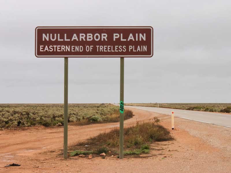
The Nullarbor Plain is Australia's most well known and most frequently travelled stretch of desert. Though the whole area of flat, almost treeless, arid or semi-arid country immediately north of the Great Australian Bight is often referred to as "The Nullarbor", the plain itself is only a part of this area.
It is in fact the world's largest single piece of limestone, and occupies an area of about 200,000 square kilometres. At its widest point, it stretches about 1,100 kilometres from east to west between South Australia and Western Australia.
Driving across the Nullarbor Plain is for many the quintessential experience of the Australian Outback. It is the ultimate Australian Road Trip and one every Australian should do at least once in their lifetime.
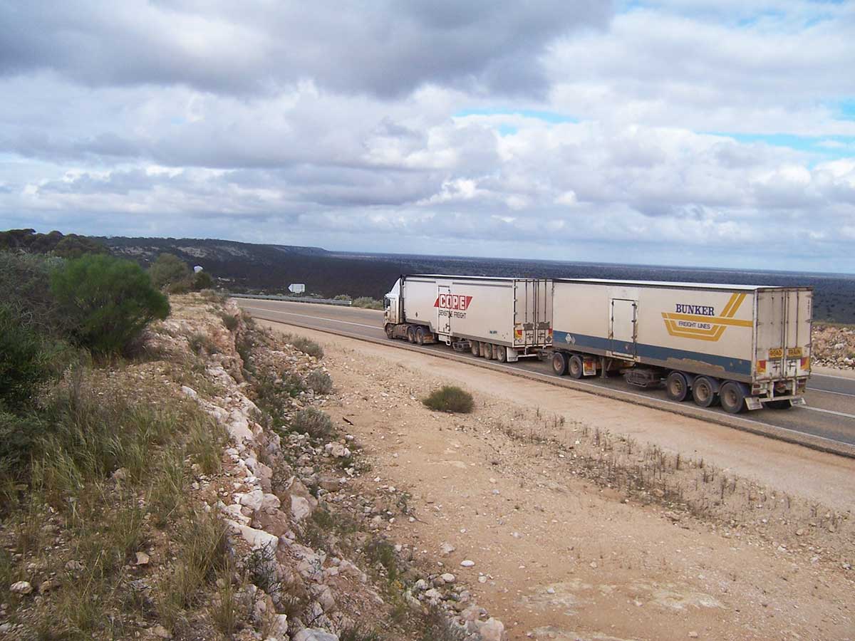
Crossing the Nullarbor in the 1950s and earlier via the Eyre Highway was a journey in which drivers literally took their life into their hands. Most of the road back then was at best an unsealed dirt track and roadhouses were few and far bewteen. Significant improvements were made to the highway in the 1960s and the WA Government had sealed the its sector right up to the SA border by the late 1960s. The last section of road to be sealed - around 200 kms of highway up to the state border on the South Australian side - was opened in July 1976. Today, the surface is sealed all the way, the road is wide and the longest stretch between roadhouses (fuel, food and accommodation) is 191 km. There is plenty of traffic on the road so if you need help or assistance, it's a short wait until the next vehicle comes along.
You don't need a four wheel drive vehicle, the average family sedan will handle the trip with ease provided it has good tyres, is in good roadworthy condition and you don't push it beyond its capabilities. Service stations at many roadhouses are equipped to handle running repairs to vehicles, though you may experience delays of up to 5 days if parts have to be brought in by truck from Perth or Adelaide.
If you are contemplating a drive across the Nullarbor, there are a number of things you need to consider in the planning stages. The first is the time factor. If you are in a hurry and want to get to the other side of the continent as fast as you can, give serious consideration to leaving your car at home and flying (5 hours between Perth and the eastern seaboard) or taking the train (3 days between Perth and the eastern seaboard). Driving at night between dusk and dawn is dangerous, even if you are sharing the driving among a number of people. This warning is not given just because of the dangers of driver fatigue; it is at dusk and dawn in particular that animals are up and about and stray onto the road. If you hit a camel, a wombat or a kangaroo, you can do serious damage to your vehicle, as well as cause serious injury or even death to yourself and your passengers.
The idea that it is a boring trip so you need to get it over and done quickly is a fallacy. Yes, stretches of the drive can be monotonous, but it is much less boring if you take time to stop, stretch your legs and look at the things that are available to look at on the way. This breaks the monotony of a long drive and makes the trip feel as though it has been worthwhile when you reach your destination.
How long a trip across the Nullarbor will take depends on your start and finish points and whether you want to take the most direct routes before and after the Nullarbor section of the drive, which is the 1,201 kms between Norseman in WA and Ceduna in SA. This is the most tedious part, and takes a day and a half to cover if you put in 10 hours driving per day.
On the WA side, from Norseman to Perth you have the choice of going north via Kalgoorlie or south via Esperance and Albany. At 814 kms, north is the more direct route and can be covered in a day, including a quick visit to Kalgoorlie and Coolgardie. The southern route is by far the more scenic. A full coastal drive which takes in Esperance, Albany, and Margaret River is around 1,400 km in length (you can reduce that by over 300 km by going straight to Perth from Albany) and includes some of the best scenery on offer in southern WA. Allow 4 to 7 days travel time between Norseman and Perth if you want to see everything worth seeing on the way. If your drive is a return trip with two Nullarbor crossings, we suggest you go via Kalgoorlie in one direction and Albany in the other.
On the SA side, you have two choices upon arrival at Ceduna. Here you can head either south or east. A 5-hour drive on the Eyre Highway to Port Augusta is the most direct route (467 kms), it passes through spectacular granite country around Wudinna, and the Iron Knob iron ore mines and township. The longer route follows the coast of Eyre Peninsula south to Port Lincoln, then north via Whyalla to Port Augusta (763 km). It will add at least one extra day to your journey, but includes some spectacular seascapes on a coastline unlike any other in Australia and is well worth the extra kilometres.
If the idea of driving across the Nullarbor in both directions is a bit daunting, you can always travel one way by car and return on the Indian Pacific train and take your car with you. This affords 2 or 3 days of lounging around on the train before or after your big drive. The train travels further inland than the Eyre Highway, so the scenery is quite different.
Which direction you drive and which you take by train is a matter of personal choice. An advantage in driving west to east is you are not driving into the sun during the hottest part of the day, which occurs when you drive the other way. But you do lose some driving time on the Nullarbor when you change time zones at the SA/WA border. Going the other way you wind your clock forward 1 1/2 hours (2 1/2 hours during daylight savings), giving you more driving hours on the longest driving sector, which is when you most need it.

The Nullarbor Plain is desert country so temperatures are at their extremes (hot days/cold nights) in summer. Winter is the most comfortable time to travel however nights can be quite chilly and the small amount of rain that does fall here falls in winter. The rain tends to bring out animals at dawn and dusk to drink from water that collects by the roadside, so avoid travelling in half light. May and September is the whale watching season.
The wildflower season ranks as one of Western Australia's most fascinating and precious natural treasures. Wildflowers are in bloom from June to November in the central and northern regions of the state, coming to life with the winter rains. In the south (Albany, Esperance, South-West) wildflowers begin to bloom in early September and remain a carpet of colour until the beginning of summer.
The Nullarbor Plain is by no means devoid of things to see along the way. Between Ceduna and Norseman, which is the most isolated stretch of the journey, there are a few surprises in store for those unfamiliar with the Nullarbor. Here are some of the things can see and do on your journey.
on the Eyre Highway.

An important service town for the central Eyre Peninsula Wheatbelt the town of Wudinna is the gateway to the Gawler Ranges. It is also at the centre of South Australia's Granite region. It was formed about 1500 million years ago, the granite outcrops in the northern section of the Eyre Peninsula are part of the vast Gawler Craton. The region has many granite outcrops that are interesting to visit and quite photogenic. The pick of them are Pildappa Rock, Mt Wudinna, Corrobinnie Hill, Tcharkuldu Rock, and Murphys Haystacks, the most southerly outcrop in the Gawler Ranges granite belt. Wudinna is 257 km west of Port Augusta on the Eyre Highway.
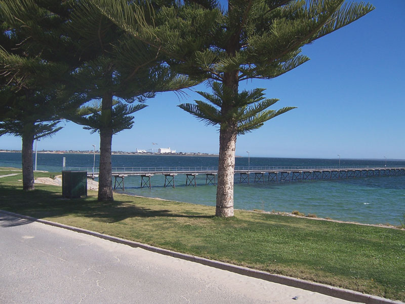
A small town in the West Coast region of South Australia that is the last major settlement before crossing the Nullarbor Plain from east to west. It is also the western gateway to the Eyre Peninsula and the south eastern reaches of the Great Australian Bight. With a population of around 2,500, Ceduna is set on Murat Bay and the sandy coves, sheltered bays and offshore islands of the bay make it a popular base for a beach holiday.
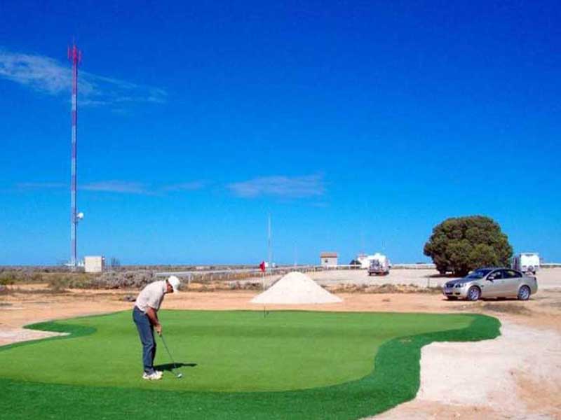
The Nullarbor Plain is not the home of Australia's longest gold course, it is the world's longest golf course. In a bid to make travellers slow down and spend more time there, a few enterprising business people along the Eyre Highway have created a golf course which takes the length of the Nullarbor to complete.
The eighteen holes are spread over 1,365 km of outback terrain; a game of golf can take as long as seven days to complete - longer even, if you keep on hitting your balls into the scrubland or suffer the indignity of having them stolen by an errant dingo or chewed by a feral camel.
The idea is that after playing one hole, you drive to the next ... and then the next. The only difference to any other golf course is that the next hole is generally 100 km further down the highway. It's a par 72 course, and bright yellow warning signs alert golfers to wayward wombats and even kangaroos on the way. Golfers can tee off at either Kalgoorlie or Ceduna, depending on which direction they are travelling.

Formerly known as Yalata, Fowlers Bay is a small coastal town not far from Nullabor Station. Edward John Eyre set up base camp here in 1840 during his epic journeys across the Nullarbor Plain. By this time the area was well-known to American and French whaling ships. The adjacent pristine waters abound with a great variety of fish, which may be caught from the jetty, cliffs, beach or boat. The frequent sightings of whales (June - September), dolphins and sea lions make visting Fowlers Bay a special experience.
in the 1950s, the Ooldea Aboriginal community was moved to Yalata from the Maralinga desert area to the north prior to the commencement of nuclear testing there by the British. The Yalata Aboriginal Reserve runs on either side of the Eyre Highway from Nullarbor to the Nundroo Roadhouse and includes about 100 km of the coastline of the Great Australian Bight.
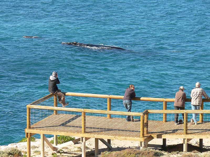
Not far from Nullarbor Roadhouse on the Eyre Highway is the turn-off to the an ocean lookout at the head of the Great Australian Bight. As well as offering views east to seemingly endless sand dunes, and west along the face of the Bunda cliffs which line the shore for 200 km right to the WA border, it also offers to opportunity to see Southern Right Whales carving between May and September. For some unknown reason, Southern Rights have chosen this spot for that purpose and travellers have the privilege of viewing mothers and children at close range. A small entry fee is charged for access to the whale viewing platform. During the non whale watching season entry is by gold coin donation only.
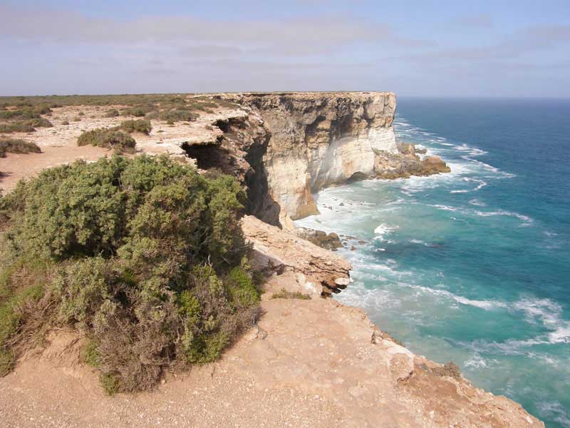
These iconic cliffs line the shore of the Nullarbor Plain and head of the Gt Australian Bight on the South Australian side for 200 km right to the WA border. They are around 70 metres in height and are the remains of an ancient ocean bed that was subject to geological uplifting millions of years ago. Something remarkable to ponder is the fact that as you drive across the Nullarbor you are in fact driving accross the floor of an ancient sea bed. On blue sky days, the sight of these cliffs are truly hypnotic and awe inspiring.
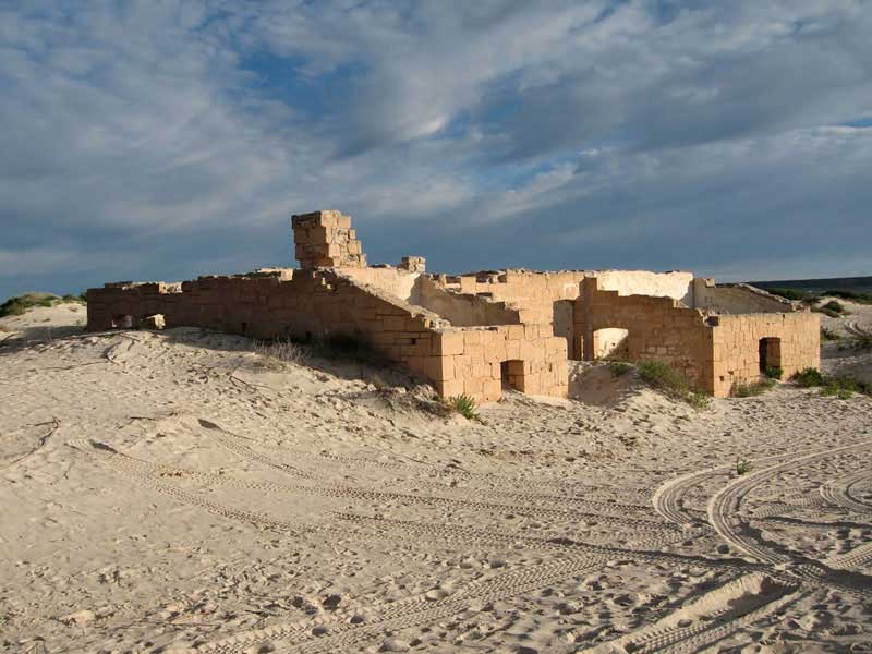
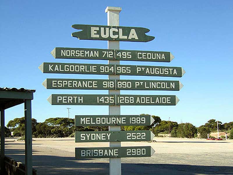
Over the border into Western Australia is the small village of Eucla which was once the site of a telegraph station on a line built joining east and west in 1877. The remains of the long abandoned station lie half buried beneath the sandhills.
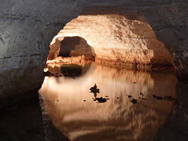
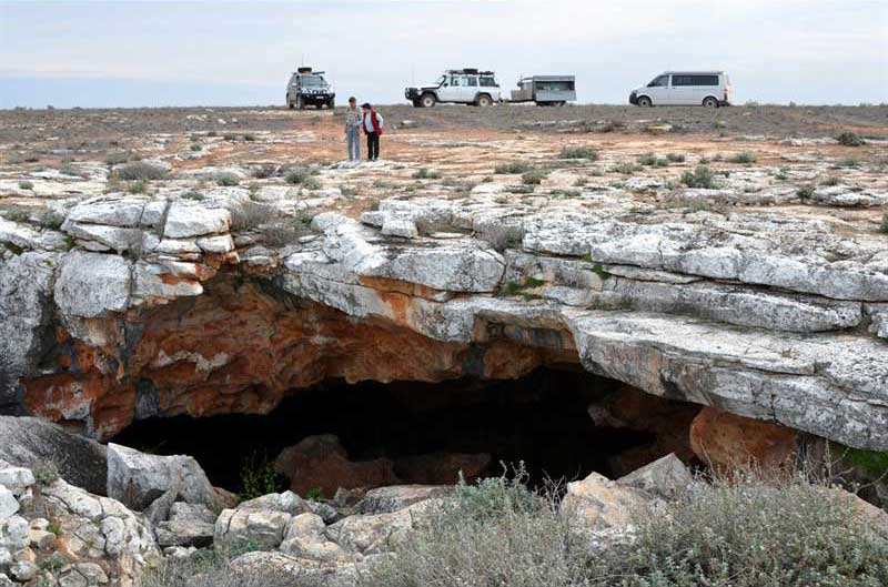
There are a number of limestone caves around Eucla. Koonalda Cave features a huge 40 metre entrance into a 20 metre drop which eventually goes to a lake over 100 metres below the surface of the Nullarbor. There are ladders and walkways but the entrance to the cave is dangerous and entry should only be attempted by experienced speleologists.
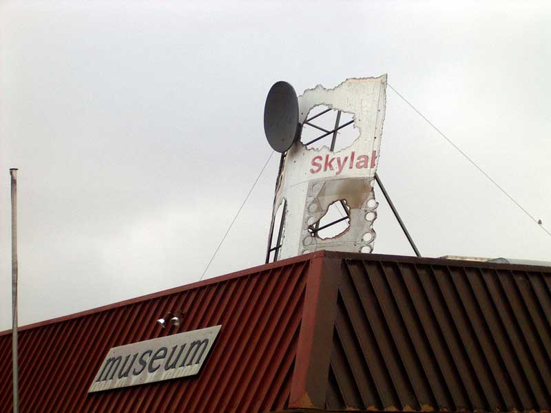
A 146.6 kilometre section of the Eyre Highway to the east of Balladonia is the longest straight stretch of road in Australia. Balladonia, which is the last roadhouse on the WA side, had its five minutes of fame in 1979 when the Skylab space station crash landed over the Nullarbor plain. It spewed lots of debris into the bush around Balladonia. The locals collected the largest pieces and it is now on display at a museum attached to the Balladonia Roadhouse. Amusingly at the time, the local Dundas Shire Council presented NASA with a littering fine, and President Jimmy Carter even rang the Roadhouse to make his apologies. The whole issue was something of a good natured diplomatic event with Canberra's American Ambassador visiting the region to inspect any damage that may have been done.
90m under the sun scorched red dust of the Nullarbor lie some of the worlds largest underground cave systems, spreading for mile after mile of cold cavernous darkness. These caves have been formed over thousands of years out of the limestone that lies under the plain. Once you leave the glare of the sun, the caves are awesome. Weebubbie, the main entrance is more like a quarry than a cave and, Cocklebiddy are among the largest tunnels in the world, and they lead to enormous subterranean lakes.
This is a hot, dangerous remote place to be and is the kind of place people have passed over for years but never explored. The caves you enter are a long way from medical help and some extend over 5 km into dark tunnels, often interrupted by high dry chambers it is easy to get lost in.
The preliminary descent into the cave mouth is relatively easy, there are ladders and hoists for your gear and you can still see the sky and feel the warmth coming off the orange rock, it's once you suit up and get into the literally crystal clear water and darkness that it gets challenging. Most visitors make it to the Rockpile, a dry pocket about 1 km in and admire the clear water, the boulders and the interesting shapes of the tunnels then turn around, but if you go deeper you'll see more of the worn limestone sculptures of the earth's interior.
If cave diving is now the world's most dangerous sport then the Nullarbor caves must be some of the world's most dangerous places.
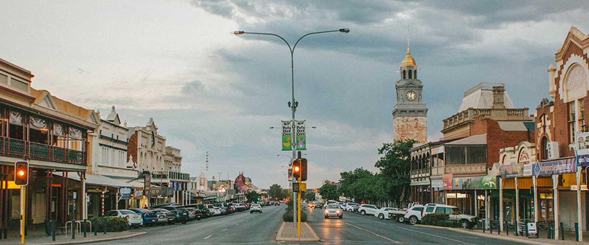
A frontier mining town at the WA end of the Nullarbor, Kalgoorlie has refused to lay down and die, and ith its sister city, Boulder, remains one of the most prosperous rural mining cities in Australia. Places - famous or infamous - that Kalgoorlie is noted for include the goldfields railway loopline, designed by C. Y. O'Connor, which brings in fresh water from Mundaring Weir near Perth; its two-up school; the Paddy Hannan statue/drinking fountain; the Super Pit (a giant open-cut mine); and Mt. Charlotte lookout. Its main street is Hannan Street, named after the town's founder; its Hay Street infamous brothels (the street itself was apparently named after Hay Street, Perth). One of the brothels has since been turned into a museum and is a major national attraction.
The Nullarbor was inhabited by the semi-nomadic Spinifex Wangai Aboriginal people. European settlers were determined to cross the plain, despite the hardships created by the nature of the Nullarbor. Although Edward John Eyre described the Plain as "a hideous anomaly, a blot on the face of Nature, the sort of place one gets into in bad dreams", he became the first European to successfully make the crossing in 1841.
In 1866 E. Alfred Delisser surveyed the Nullarbor Plain and noted a marked absence of trees. Contrary to some popular opinions the word Nullarbor is not of Aboriginal origins. In fact the local Mining people referred to the area as "Oondiri" which is said to mean "the waterless". Delisser derived the term Nullarbor from the Latin "nulla" for no, and "arbor" for tree. Hence the term Nullarbor meaning no trees.
In the 1870s and 1880s vast areas of the Nullarbor were leased to sheep graziers with many sheep stations later being incorporated into the vast Fowler's Bay run that stretched from Streaky Bay in the East to areas even further west of Nullarbor Station - a distance of over 400 kilometres! Today just about all that remains are abandoned homesteads. Koonalda homestead is one such abandoned site that the traveller can visit and use as accommodation, or as a base to explore nearby Koonalda cave and other limestone sinkholes within the area.
A new state of Auralia (meaning "land of gold") was proposed in the 1890s which would have comprised the Goldfields, the western portion of the Nullarbor Plains and the port town of Esperance. Its capital would have been Kalgoorlie.
In the 1950s, the Wangai Aboriginal people were forced to abandon their homelands during the British nuclear tests. Since then they have been awarded compensation and many have returned to the general area. In fact, many never left. Due to their isolation it was impossible to warn them all about the testing.


Design by W3layouts