Contained within approximately 563km of coastline, Yorke Peninsula stretches officially some 241kms, from Cape Spencer in the south through to Port Broughton in the north and separates the Spencer Gulf (to the west) from the St. Vincent Gulf to the east. At its widest (at Arthurton), the Peninsula is only 48km from coast to coast and this narrows to 32km down south. Around 12,000 people live on Yorke Peninsula in 12 main towns and 33 townships. It has been said that there is no such thing as a free lunch - but such is not the case on Yorke Peninsula. Here you can stroll in the shallows to catch blue swimmer crabs by the bucket-load, dive for crayfish and scallops just off-shore, or throw out a line for garfish, tommy ruffs and King George whiting.
Location: Yorke Peninsula, South Australia
Length: 563 km
Minimum duration (one way): 2 days plus recommended
As this drive visits many very interesting places with plenty to stop and look at, we recommend you allow much more than the 2 day minimum duration if you are to get the most out of a visit to Yorke Peninsula. There is far more to see and do than we have the space to document here, so we recommend you look out the visitor information centres at each of the major localities who will provide you with all the information you need to get those most out of your tour.
The drive commences in Kadina the largest town on the peninsula and one of three that makes up the Copper Triangle, a small area roughly 160 km northwest of Adelaide, the towns of Moonta, Wallaroo and Kadina being the points of the triangle. The Triangle was the home to the richest cooper mines in Australia during the end of the 19th century. The Triangle is considered by some to be 'Australia's Little Cornwall' a title perhaps taken from the fact that the first miners to the area were Cornishmen, a fact reinforced by the biannual Cornish Festival held in May.
One of the towns of South Australia's copper Triangle, Kadina is the largest town on the Yorke Peninsula, and the main commercial centre for the region. Like Moonta, it has strong Cornish influences from the migration of Cornish miners to the area in the 19th century. The area had been inhabited by Narrunga Aborigines prior to European settlement and it's name comes probably from their word 'caddy-yeena' or 'caddy-inna' which is thought to mean 'lizard plain'.
The town owes its existence entirely to the discovery of copper. In 1866 R. P. Whitworth wrote: 'The country was never considered fit for anything until one of the oldest resident settlers, Captain Hughes, discovered that under the valueless surface, there were chances of great wealth in store for himself and others. He found traces of existing copper-bearing lodes on the beach near his station, and for years tried to follow those traces back into the country, but unsuccessfully until at length in the year 1860 a shepherd [James Boor], who was remarkably intelligent man, discovered copper ore thrown to the surface by the wombats in their burrowing under the limestone crust.'
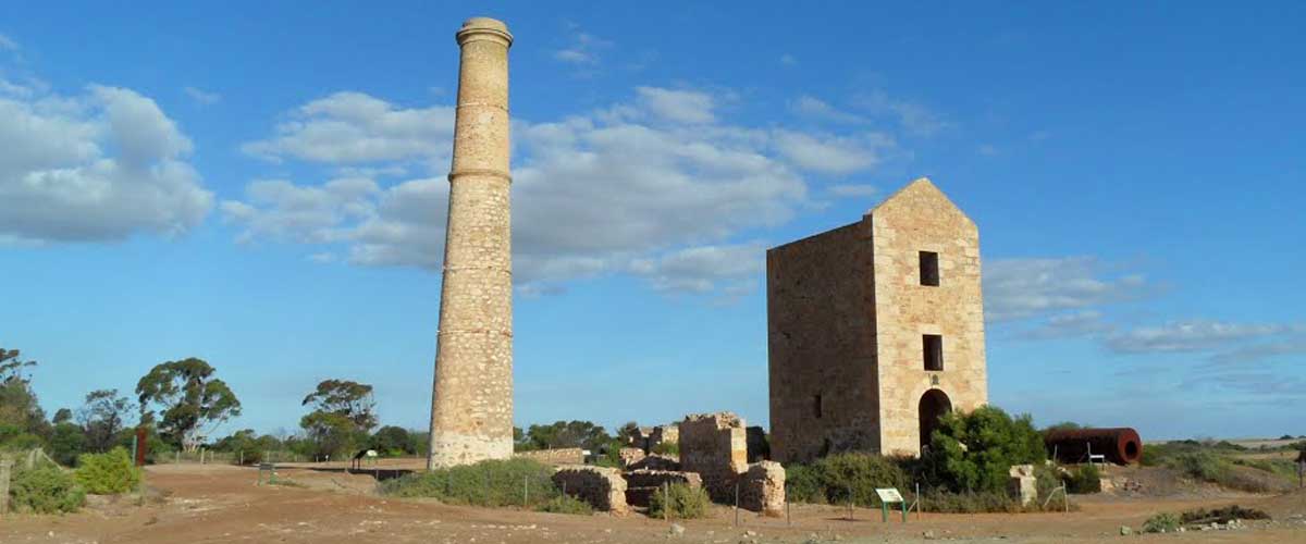
The remnants of Wallaroo Mine, located about 1.5 km south-west of the town centre (take the Moonta Road south and turn west into Matta Road), are well worth a visit. All the important destinations in the site are clearly marked and the site is easy to locate because of the stone ruins of Harvey's Enginehouse.
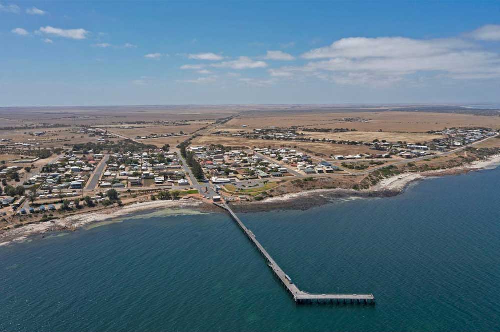
Wallaroo is a key shipping port for the Yorke Peninsula, the former copper mining centre now ships locally grown barley and wheat, processes rock phosphate and manufactures fertilisers. Wallaroo offers excellent beachfront camping/caravan facilities and a range of low energy, relatively safe beaches. The first sight the traveller has of Wallaroo is that of the looming grain silos. Here is a town which is a strange mixture of seaside resort (there are some delightful cabins beside the sea and some excellent fish and chip shops) and working, industrial town. Wallaroo's importance is based on its role as the major port for the vast copper deposits which were found and mined at Moonta.
The towns of Moonta, Wallaroo and Kadina at the head of South Australia's Yorke Peninsula are the corner points of what is known as the Copper Triangle. The richest cooper mines in Australia lay within this small area. The mines and smelters of the Copper Triangle were large establishments by world standards in the nineteenth century.
Moonta Bay
Moonta is today considered by some as 'Australia's Little Cornwall' as the first miners to the area were from Cornwall, a fact reinforced by their influence on the architecture of the town, and their cultural impact which is still celebrated with the bi-annual Kernewek Lowender Copper Coast Cornish Festival held in May.
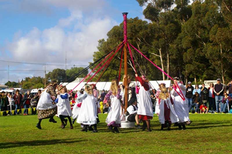
Kernewek Lowender
The largest Cornish Festival in the World, Kernewek Lowender reflects the influence of Cornish miners on the town's of Yorke Peninsula's copper triangle - Moonta (which hosts the event), Wallaroo and Kadina. From small beginning in 1973, the festival today attracts over 30,000 people to Moonta in odd numbered years in May. Renowned for its many free events, street processions, church services and art and craft displays, it gives a chance for many Australians to celebrate Cornish ancestry. Kernewek Lowender the Cornish words for Cornish happiness, really describes what the festival has come to represent.
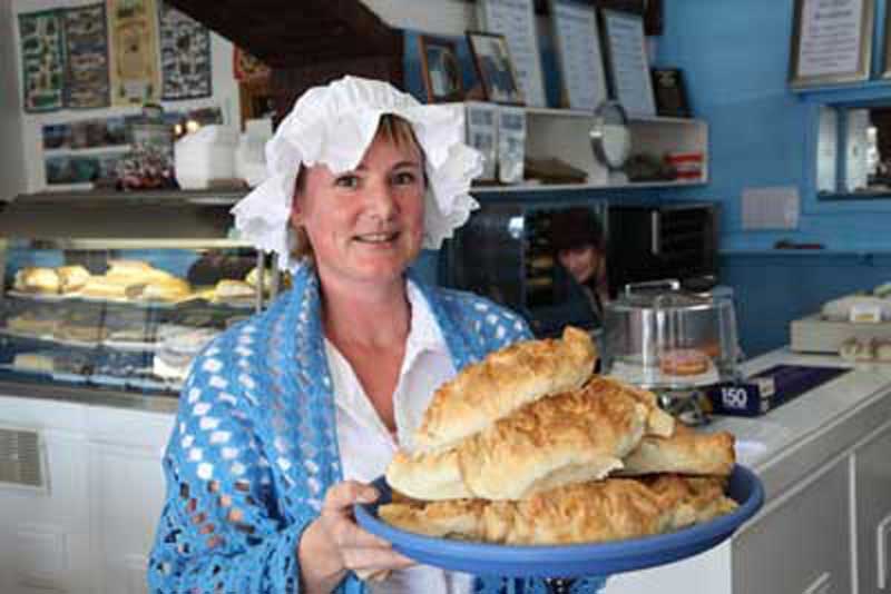
One of the things Moonta is most famous for is the Cornish Pasty. Cornish miners used to take their lunch to work in a package of pastry - so it wouldn't get dirty. The pastry was joined along the top with a ridge so that it could be easily carried. The miner would open the pastry, and find in one end meat and vegetable; the other end would have fruit and jam for dessert. Moonta and other 19th century copper mining towns around South Australia, attacted miners from Cornwall in England, who brought with them their culture and traditions, which included the Cornish pasty.
Today you can still buy delicious meat and vegetable filled traditional pasties in Moonta. The Cornish Kitchen in Moonta is famous for their authentic and original Cornish pasties and the home of the Cornish Pasty in Australia. On an average day this bakery produces 300 to 400 pasties a day, some of which are sent all over the country. The Cornish Kitchen, Ellen Street, Moonta.
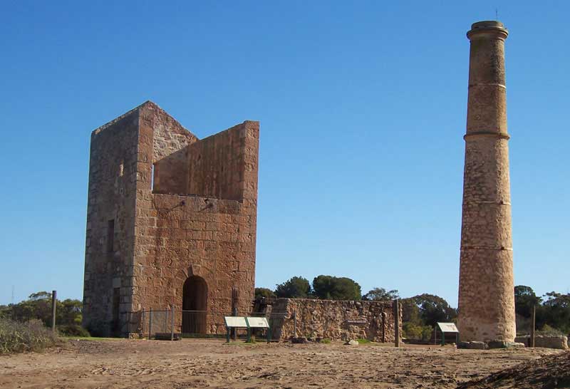
Moonta Mines, 2 km away from the town, is the site of the town's legendary copper mines. Most of the old infrastructure remains, including mine shafts, enginehouses, waste dumps, railway tracks and Cornish miners' cottages. Many relics from Kadina's copper mining days can be found on the outskirts of town. The port of Walleroo has an excellent maritime museum.
Hughes Pump House is today a ruin but from the time it was built in 1865 to the closure of the mine in 1923 it pumped water from the neighbouring mine shaft as well as the nearby Taylor's Shaft. Today, it forms part of the Moonta Mines State Heritage Area, which also includes Richman's Engine House (1869).
Mining relics at the mine at Wheal Hughes Mine, an old miners cottage nearby, a Methodist church and the old school, which is now a folk museum, tell the story of the Copper Triangle. Mining relics can also be seen at Wallaroo and Kadina.
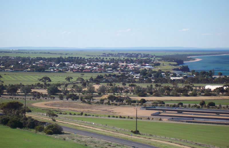
A town with a population of around 1,000, Maitland is known as the "heart of Yorke Peninsula" due to it being near the centre of the region. By road, it is 168 km west of Adelaide, 164 km south of Port Pirie and 46 km north of Minlaton. Maitland is within a short driving distance of coastal towns on either side, with Port Victoria to the west and Ardrossan to the east, each being within 25 km from Maitland. Though the town still a has a grain receiving depot operated by AWB Limited, wheat and sheep, that have traditionally driven the peninsula's economy, still survive, but tourism now plays an ever increasing role in keepng the town's economy ticking over.
Though much smaller than Adelaide, the town was laid out in the same style and following the same priciples as the capital's design, with a series of radiating squares. On the outer edge are North, West, South and Shannon Terraces. Road radiate in from the corners of this square; there is a smaller square and then two smaller squares. In that respect it is not your typical Australian town, but it certainly is typically South Australian.
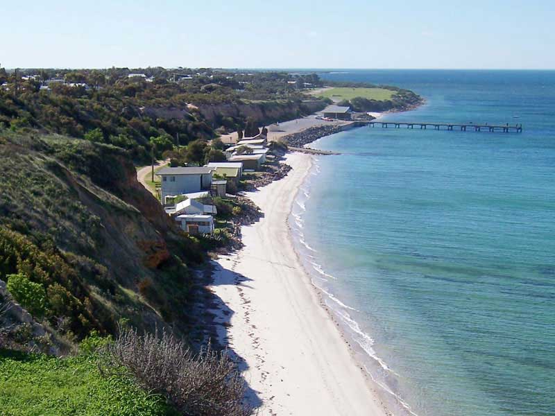
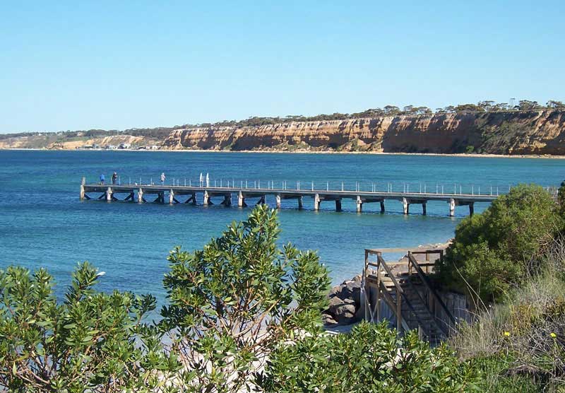
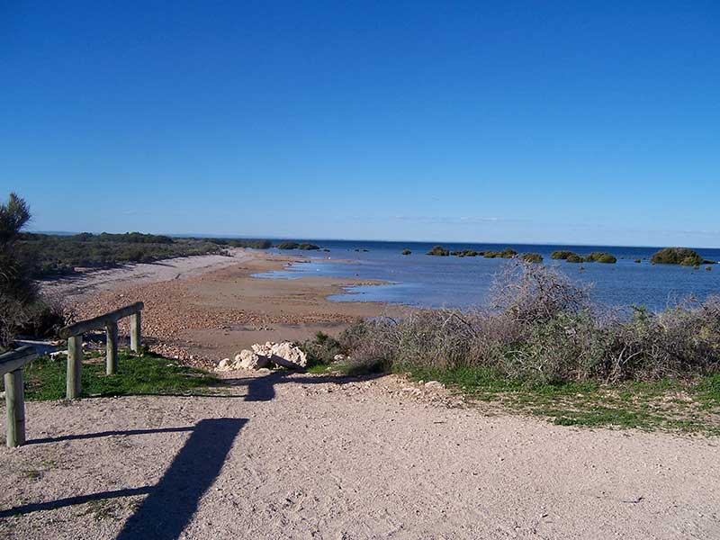
Upon leaving Maitland, our drive heads for the coast on a 20 km drive to Balgowan. The town was once a busy shipping port, but with the advent of bulk loading at Ardrossan and better roads with motor transport, little shipping ports such as Balgowan fell into disuse. Today it is a small fishing community and popular holiday area for families and fishers with a reputation as one of Yorke Peninsula’s best locations for catching snapper and King George whiting.
The town itself sits on 20 metre high bluffs with spectacular sea views over the first of four west facing beaches that extend north of the town for 5 km to Tiparra Rocks. All receive low wind waves and are fronted by continuous seagrass meadows. Seagrass meadows lie 20 m off the shore and steep red alluvial bluffs back the beach.
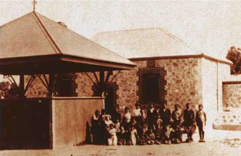
Travelling south from Balgowan, the road goes inland and through the settlement of Point Pearce. Also known as Point Pierce, it was one of several missions established in South Australia in the late 19th century. Soon after the establishment of Adelaide in 1836, white settlers had begun moving into Yorke Peninsula. The British concepts of property ownership were incompatible with the Narunggas' nomadic lifestyle, resulting in the gradual displacement of the Aboriginal population. Point Pearce, a favoured camping location of the local Narrunga Aboriginal people, especially during dry seasons, was chosen as the site for an Aboriginal Mission for the region in 1867.
In 1868, the Point Pearce Aboriginal Mission was established by the Moravian missionary Reverend W. Julius Kuhn. Some of these missions, which included Poonindie (1850), Point McLeay (Raukkan, 1850), Killalpaninna (1866) and Koonibba (1898), were the basis for Aboriginal communities which persist until the present; they were among the few places in the southern part of South Australia where dispossessed and displaced Aboriginal people were welcomed. In 1874 the Point Pearce Mission Station reserve was extended by another 31 km2, and including Wardang Island. By 1878, the mission was largely self-sufficient from its wool and wheat income. In 1972, ownership was transferred to the Point Pearce Community Council under the Aboriginal Lands Trust Act 1966. Many of the buildings remain today.
Situated on the shores of Spencers Gulf midway along South Australia's Yorke Peninsula is the small town of Port Victoria. Like the other unassuming coastal towns on the Peninsula, it could be described as a sleepy backwater, but is one of the historically important settlements in South Australia. Its romantic connection with the age of sail and the great clipper ships gives the town the right to call itself 'the last of the windjammer ports'. As recently as 1949 windjammers were still sailing into Spencer Gulf, mooring offshore and being loaded with 180-lb (80kg) bags of wheat before heading south to the Roaring Forties, rounding Cape Horn and making their way to the markets of Europe, mainly Falmouth, England or Queenstown, Ireland.
Wardang Island is one of South Australia's premier dive locations. A Heritage Dive trail showcases eight of nine shipwrecks around the island, which are associated with the trading port of Port Victoria in the early 1900s. Of the wrecks, five are of schooners and coastal steamers – the Monarch, S.S. Australian, S.S. Investigator, MacIntyre and Moorara – that carried wheat and other local cargo, and three – the Aagot, Notre Dame D’Arvor and Songvaar – are larger vessels that transported grain to Europe. The island is an Aboriginal reserve, sacred to the Narungga peoples.
Yorke Peninsula is one of South Australia's key diving areas. With such a combination of unspoilt ocean and gulf waters and habits, including sandy beaches, reefs and islands, there is a huge diversity and abundance of fish and cristacean species. Two Underwater Maritime Heritage Trails provide excellent diving opportunities for beginners and the experienced. The Wardang Island Maritime Heritage Trail has eight wrecks within 10 nautical miles of each other, while the Investigator Strait trail highlights 10 vessels wrecked in that region.
The Yorke Peninsula is well known for its pristine beaches, turquoise water and amazing camp sites, and Wauraltee Beach is one that has helped the Peninsula to earn such a reputation. Miday between Port Victoria and Port Rickaby, Wauraltee is at the end of a reasonable (but corrugated) gravel road. Apart from one toilet it has no facilities, not even rubbish bins so if you plan to camp here - and many people do, right on the beach - bring everything and you need and be prepared to take it all away with you when you leave. Camping is free. The $20 Bush Camping Permit issued by the local council only grants access to the campground, not the beach area, which is not under their jurisdiction. Access is via a public road, so all road rules apply and unregistered vehicles are not permitted. Anyone familiar with this coast will already be aware that its sunsets are stunning.
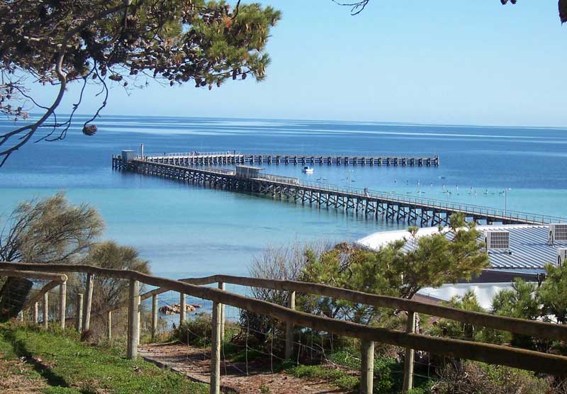
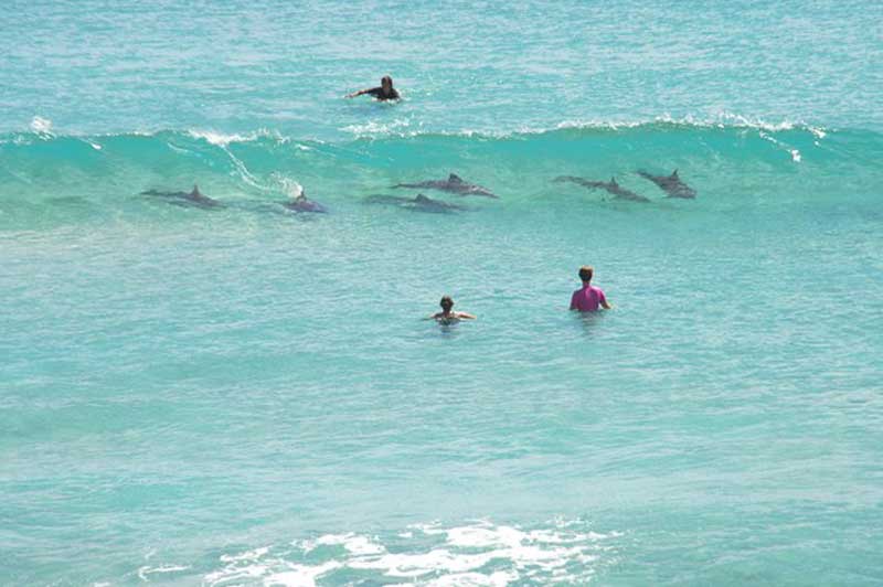
Port Rickaby is a quiet holiday destination on the coast, located in lee of a 1.1 km long sand beach, fronted by relatively narrow 60 m wide sand flats. A 100 m long jetty crosses the flats providing access to deeper water and in past days a berth of the wheat ships. The port is dominated by a large beachfront caravan park, and large car park to service the boat ramp and beach users. There is also a store with fuel available. It's an all-round ideal location for families, offering good swimming and fishing (whiting), sand dune surfing, sea kayaking, paddlebording (often with wild dolphins) and beautiful surises and sunsets.
Port Rickaby offers one of the nicer swimming beaches on the western peninsula, as well as a well developed caravan park, jetty and other facilities. The jetty is a popular location for shore-based fishing.
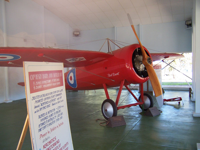
A small inland town which services the numerous small communities and coastal resorts of the Yorke peninsula. It is surrounded by sheep, barley and wheat farms. Minlaton modestly refers to itself as the Barley Capital of the World. It was the home of pioneer aviator, Harry Butler, who flew the Red Devil, a 1916 Bristol monoplane. The Captain Harry Butler Memorial is the town's major attraction and has Butler's extraordinary Red Devil preserved and on display inside. Captain Harry Butler purchased this plane from the British government and shipped it to South Australia in 1919. He first used it to carry airmail from Adelaide to his home town of Minlaton on 6 August 1919, it being the first flight across sea in the Southern Hemisphere by any plane. The Red Devil was then flown by Captain Butler for joy rides, barnstorming and peace loan promotion. The plane was modified in 1931 and fitted with 110 horsepower De Havilland Gypsy engine. It was last flown in 1945.
The Minlaton Walking Trail starts at the Visitor Information Centre and heads north along the Main Street to the H J Cook Fauna Park, which contains emus, wallabies and kangaroos. It passes the town's basketball courts, meandering through bush and along the edge of the golf course. Along the walk there are interpretive signs regarding the River Red gums - Minlaton is the only area on the Southern Yorke Peninsula that these trees grow naturally. There are also signs telling of the early settlement of the area, which was known as Gum Flat.

Parsons (or Watsons) Beach extends for 8.3 km from 2 km north of the old port to the southern rocks of Bluff Beach. There is a small town at the north end of the locality, set behind the sandhills from the beach. A boat ramp is accessible via the northern Bluff Beach settlement, which overlooks Hardwicke Bay. All these beaches experience generally low wind waves or calm conditions, with swimming only possible at high tide when the rock and sand flats are covered; however be careful of the extensive rock flats.
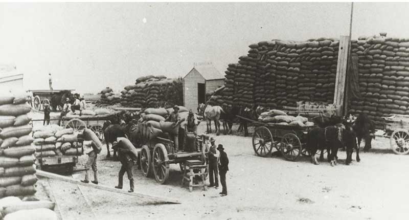
Photo: State Library of South Australia - B 32225
A jetty was built at Minlacowie in 1877 for the shipment of wheat grown on the peninsula to Port Adelaide by steamers. The jetty was built of redgum, the piles and bearers being all of jarrah. A township has been surveyed at Minlacowie, but as at Point Turton, no buildings have yet been erected. Minlaton, 16 km distant, was the nearest township to the Minlacowie jetty, and the intervening country was heavily cropped with wheat and barley. The Jetty was demolished in 1971.

Today the area where bags of grain were stacked prior to shipment is a bush campground with a toilet. Just north of the campground is a boat ramp. No other facilities are provided, camping fees apply. The beach here is all rocks with little or njo sand. Access to Port Minlacowie is via Minlacowie Road and Beegoodye Wells Road.
Known respectively as the “original shack site” and then “Moorowie Shack Site", Hardwicke Bay is a popular seaside holiday spot 9 km north of the town of Warooka. As its earlier names suggest, it has bagan a small beach shack settlement for locals and weekeders, and a base for professional fishermen since the 1940s. It is now a popular mix of shacks, permenant and holiday dwellings with a general store.
Its sheltered bay is perfect for swimming, fishing, boating, yachting and windsurfing, all of which are popular pastimes on Yorke Peninsula, especially during holiday season. This peaceful town offers everything for anyone wanting to relax and looking for the great escape. 200 metres south of Hardwicke Bay is a natural swimming pool surrounded by a reef. King George whiting is often abundant in this area, making it popular for fishers.
The bay, along with the peninsula, were named by British navigator Matthew Flinders after Philip Yorke, 3rd Earl of Hardwicke (1757-1834), Member of the British Parliament for Cambridgeshire, later for Liskenard. Yorke became First Lord of the Admiralty in 1810. Yorketown was subsequently named after Philip Yorke also when it was established.
Flaherty Beach is a magic strip of endless clean white sand extending from Point Turton to Hardwick Bay. The clear shallow water is perfect for kids and for an enjoyable time with family and friends. There is four wheel dive only access to the beach but it is just a short walk from the car park off Corney Point Road. A long, long walk through the beautiful shallows and a further long walk to reach waist high water is a relaxing way to spend an afternoon. The young ones will enjoy finding shells at the edge and even dig your feet in for a feed of cockles albeit smaller than Goolwa cockles but just a tasty. A great day out for the family or groups.
Point Turton overlooks the beautiful blue waters and white beaches of stunning Hardwicke Bay where the peninsula's 'leg' meets its 'foot'. The sheltered waters are near-perfect for year round boating, sailing, windsurfing, diving and fishing. The jetty at Point Turton was built in 1876 to ship out the local barley, and stone; the quarrying of stone ended in 1917. After this, the jetty was used for a number of reasons including the shipment of grain, superphosphate, heavy freight and local provisions. The jetty is now popular with fishers and used for unloading the local catches of salmon and prawns. The old quarry site is now the Point Turton Caravan Park, adjacent to the boat ramp and jetty.
The small town of Warooka, nestled on a low range of hills known as Peesey Range, is located 250 km west of Adelaide and 21 km west of Yorketown. On 9th September, 1902, Yorke Peninsula was shaken by a severe earthquake. Sir Charles Todd, Govt. Astronomer at the time, calculated the epicentre to be at Warooka. The shock was severe enough to stop the Glenelg Town Hall clock in Adelaide and was felt down in the south east of South Australia and to the north as far as Orroroo. The earthquake, which lasted three minutes, caused the brick chimneys of the hotel to collapse and at least two houses were severely damaged.
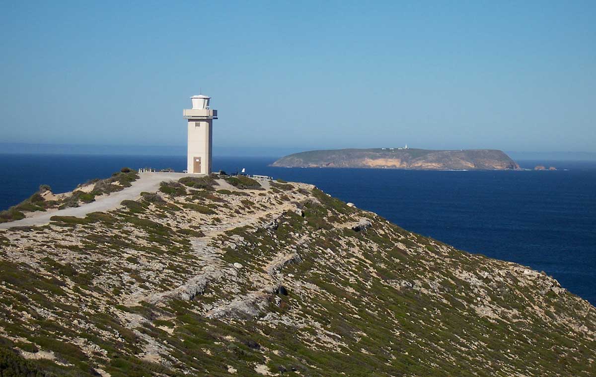
A coastal holiday and fishing settlement on the northern section of the "toe" of Yorke Peninsula, Corny Point is the gateway to a picturesque section of coastline on the western tip of the peninsula 7.5 kilometres away, between Corny Point and Stenhouse Bay. Corny Point offers sheltered beaches as well as some excellent surf beaches within 15 minutes drive, including Rock Pool, Salmon Hole, Daly Head and Berry Bay. The lighthouse, which was completed in 1882 and is 12.2 metres high, was built of local limestone. It ceased being manned in 1920. The locality was named Corny Point by Captain Matthew Flinders in 1802 due to the fact that it looks like a growth on the toe of the Yorke Peninsula.
West Beach, beyond Corny Point, is a surfing beach with persistent beach rips, so be careful, while the rocky point beach is unsuitable for safe swimming. The protected point beach offers the safest swimming. These are all relatively high energy beaches on the western peninsula, with good views from the backing bluffs and Corny Point.
Marion Bay is situated right on the 'foot' of Yorke Peninsula, and with it comes a total change of secenery both on land and in the ocean waters that surround it. With surf and swimming beaches and a variety of fishing available, visitors are sure to enjoy this small town. With a sheltered swimming beach on one side and a surf beach on the other, it’s the perfect spot for a salt water fix. The town is also a popular fishing destination with plenty of spots to cast a line and try your luck beach, jetty, rock and surf fishing. Marion Bay is the gateway to Dhilba Guuranda-Innes National Park, which occupies the southwest tip of Yorke Peninsula.
offers the safest swimming. These are all relatively high energy beaches on the western peninsula, with good views from the backing bluffs and Corny Point.
Located at the tip of Yorke Peninsula, Dhilba Guuranda-Innes National Park is one of the most spectacular coastal parks within Australia. With its diversity of habitats, and an abundance of heritage and coastal scenery, Innes provides a wide variety of recreation opportunities, including bushwalking, photography, camping, surfing, diving, fishing and surfing. There is an abundance of history associated with mining gypsum in the early 1900's; the historic heritage-listed Inneston village where gypsum used to be mined is open for inspection. The park comprises 9,415 hectares of coastal vegetation, contributing to one of the few large areas of significant vegetation on the Yorke Peninsula. Spectacular coastal landscapes with rugged cliffs and sandy beaches provide the Park's backdrop.
West Cape
The National Park is one of only a few places in the world where living stromatolites are known to exist. Stromatolites consist of layers of blue-green algae (or cyanobacteria). New layers develop on top, closest to the light, trapping whatever silt may be present. Old layers underneath are impregnated with calcium carbonate and become fossilised. In this park, the dome-shaped structures occur around the edges of the salt lakes. Carbon dating has indicated some of the stromatolites to be around 3,000 years old. Examples of stromatolites can be seen at the park's visitor centre.
This historic ghost town, locatec in Dhilba Guuranda-Innes National Park. was first settled in the late 1880s after gypsum was first discovered in the area and mined. The quality of the gypsum in this area was exceptionally high class and most of Australia's needs were supplied from here. A number of the town's buldings have been restored. Inneston was a small mining and processing town with a population of about 150 people. Its short history began as Cape Spencer in 1913 and lasted until the depression years of the 1930s.
Although Gypsum had been mined on Yorke Peninsula from the 1870s, the deposits at its southern tip were not worked until after the start of the twentieth century when the Permasite Company was taken over by W.R.D. Innes. He began to mine near Cape Spencer and with his brother formed the Peninsula Plaster Company and shipped the gypsum to Melbourne until 1916 when it was processed on site.
A ghost port within Dhilba Guuranda-Innes National Park, Stenhouse Bay lies at the foot of Yorke Peninsula. Stenhouse Bay was a port operated for 50 years until 1972 by the Waratah Gypsum Company which established a community of 35 families to administer the gypsum workings; it had 37 houses, a community hall, school, post office, a licensed general store, and administration buildings. Windjammers once loaded locally mined gypsum, and limestone from quarries at Inneston. The quality of the gypsum in this area was exceptionally high class and most of Australia's needs were supplied from here.
A wide variety of fish species can be caught off local beaches or the Stenhouse Bay Jetty. You can fish in secluded locations like Stenhouse Bay, or join other anglers on the salmon run at Browns Beach. Fishing guides are available from the Visitors Centre. The bay is about 10 kilometres from Marion Bay jetty.
Butler Beach is located 14 km east of Marion Bay near the foot of Yorke Peninsula. It is usually not crowded, there's plenty of parking, with great bush camping, fishing and swimming spots and beautiful quiet sandy beaches. The area is noted for its wildlife; tortoises, pelicans, small sea birds, and flowers. It offers some of the best fishing on Yorke Peninsula. You can catch Salmon, Mulloway, Tommys and Snapper from the surf beaches. Rock fishing provides Snook, Sweep, Squid and King Fish. Alternatively, bask on the spectacular sandy beaches or observe fish, whales and dolphins in the their natural habitat.
Eco toilets are provided at the camp sites. Hot showers, laundry, water, BBQ and rubbish disposal are centrally located. A small store provides bait ice and basic supplies. Tents, camper-vans, caravans and big-rigs are welcome.
Foul Bay is located on the south coast of Yorke Peninsula immediately adjoining Investigator Strait about 130 kilometres west of the state capital of Adelaide. It derives its nsme from the Foul Bay Shack Site and also incorporates the Old Wheel Inn and the Point Davenport shack settlements. The quiet and secluded location, it provides the opportunity to explore the clifftops and coves, beautiful beach surroundings, or even the chance of sighting of kangaroos, sea lions and even Southern Right Whales passing by during the migration and breeding season. Foul Bay is also an ideal fishing spot, having a concrete boat ramp suitable for all year round launching.
The screnery changes again around Port Moorowie, with the small settlement being predominantly a collection of holiday houses and shacks spread along 2 km of low bluffs in the western corner of Waterloo Bay, called McLeod harbour. The protected section of the bay has a shallow seagrass covered floor with shallow sand flats bordering the bluffs and beaches. Apart from a boat ramp at the western end of Waterloo Bay there are no facilities at the port. Six small relatively cslm beaches are located along the base of the 5 to 10 metre high bluffs, with vehicle access to the top of each of the beaches. The hinterland is flat, with fields of bright yellow canola.
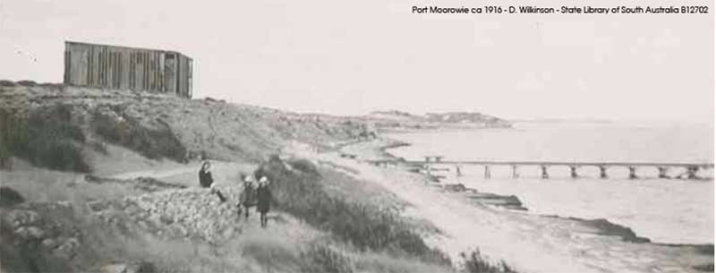
The name Moorowie, an Aboriginal for sandy water, first appeared on maps when Yorke Peninsula was used exclusively for grazing sheep and the entire area was subdivided into several huge pastoral stations. One station was called Moorowie stretched from Hardwicke Bay to the south coast. The ruins of the old Moorowie homestead can be found approximately ten kilometres west of Warooka. The pastoral era came to an end when the then government decided to launch agriculture onto the Yorke Peninsula. The town was first surveyed in the early 1870's at the same time as Edithburgh and Stansbury when agricultural selections were being surveyed. Port Moorowie was to service the new agricultural industry. Its jetty was built in 1880 but the port had always been considered “nightmare” port due to exposure to the rough seas of the Southern Ocean. Stansbury and Edithburgh grew rapidly but Port Moorowie did not, as the newly developed town of Yorketown soon became the defacto centre for the district.
Troubridge Point, located 11 kilometres south west of Edithburgh, is the most easterly point of the Yorke Peninsula coast that directly adjoins Investigator Strait. It is the termination for a pair of coastlines - one extending from Cape Spencer in the west and the other extending from Sultana Point from the north in Gulf St Vincent. It is the western end of the opening to Gulf St Vincent. The water adjoining Troubridge Point drops to a depth of 10 metres at the base of its cliff face.
The Troubridge Hill Lighthouse was built in 1980 to replace the Troubridge Shoal Lighthouse as the major coastal light in the area. It is unique in that it is built from special wedge shaped bricks and has never been rendered or painted, creating a very distinctive day mark. The tower is designed to resist earthquakes and high winds, as both Troubridge Hill and Corny Point suffered from several earthquakes in the early 20th century.
A short drive south from the town of Edithburgh and immediately adjoining the western head of Gulf St Vincent, Sultana Point has a number of beautiful beaches that are a popular spots for swimming, beach fishing and kitesurfing. Between Sultana and Wattle points is a 2 km long southeast facing beach, largely protected by the 5 km wide Tourbridge Shoals. The tiny settlement here consists of two streets of beach shacks and holiday rentals. Beyond them is Wattle Point Wind Farm. The locality's name is taken from the barque Sultana, wrecked on Troubridge Shoal in 1849.
This holiday and fishing town is located on the cliffs at the southern tip of Yorke peninsula. It overlooks Gulf St Vincent and Troughbridge Shoals, a chain of small islands. Once the third busiest port in South Australia, today it is the most popular holiday destination on the peninsula. There are nearly 200 hundred lakes, most of which are salt, in the Edithburgh area.
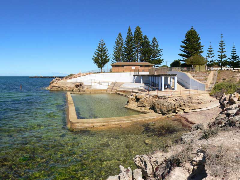
Edithburgh has great beaches that are perfect for fishing, scuba diving or snorkelling and sail boarding. A tidal pool is located on the northern foreshore reserve and is the best place for swimming. Most of the foreshore consists of crenulate, crumbling rocky bluffs, backed the a continuous grassy foreshore reserve and the main road. Three small beaches are located below the bluffs.
With a population of 969 of which 642 lived in its town centre (2016 census), Yorketown is an inland town in the southern Yorke Peninsula about 91 kilometres west of the state capital of Adelaide. The area associated with Yorketown is known as Garrdinya by the Narungga, the aboriginal people of the Yorke Peninsula. In the early days, Yorketown was called 'Weaners Flat', because it was where the pastoralists separated the lambs from the ewes. Surrounded by around 200 salt lakes, the town has a history based initially on harvesting those lakes. Today, the crystal formations are a boon for photographers and the red pink to white of some of the lakes catches the eye.
Wool Bay, a scenic spot on the shores of the gulf, consists of cliffs with a sandy beach at their base. There is an old lime kiln in the cliffs and a jetty (1900-1910) which was used for loading lime onto boats, but is now used only for recreational fishing and recreational scuba diving. There is also a boat ramp on the beach. Its name originated in the days when it served as a port for the district's farms and pastoral runs, and bales of wool were rolled down onto the beach via a cutting in the cliff there prior to shipment.
Stansbury, situated on the lower east coast of Yorke Peninsula, is a popular holiday destination with scenic views over Gulf St Vincent. The town is 17 km south of Port Vincent and 21 km north east of Yorketown. Fishers are well catered for - seasonal catches include King George whiting, garfish, mullet, Tommies and squid. Blue Swimmer Crabs can be raked from the shallows (in season), or netted from the jetty or boat. The oyster farms supply fresh, locally-produced oysters straight from the sea when in season, so keep your eye out for signs.
The Stansbury Walking Trail is a total distance of 6.3 km, along the coastline, from the town jetty to Pitts Cutting - south of the township. The three stages of the trail provide walking, cycling and disabled access to our coastal reserves, with rest areas and lookout points along the way. Along the walking trail you'll also find adult gym equipment, which can be used in conjunction with your walk.
A popular home for retirees and destination for holiday makers located 15 km north of Stansbury and 42 km south of Ardrossan. Port Vincent has grown in size over the last few years with the release of land for housing. It is the site of a major marina and a small fishing fleet. The Marina is the resting place for many biennial Saltwater Classic yachts, and for a number of the larger cruisers alongside some of the newer and larger homes in the town.
It is also home to the famous maxi yacht, Brindabella, that won line honours in the 1997 Sydney to Hobart Yacht Race as well as breaking the race record for a conventionally ballasted yacht in 1999.
Initially called Surveyor's Point, the town of Port Vincent was laid out by an Adelaide Solicitor in 1877. Like most of the towns on the Yorke Peninsula, Port Vincent is an old port. It was once one of the old landing spots for the ketches going up and down the peninsula. In the 1900s a jetty was built and the port used to ship locally grown grain until 1970.
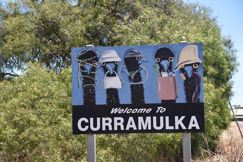
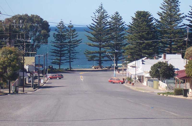
The inland farming community of Curramulka is one of the oldest townships on the Peninsula, being proclaimed on 31 December 1874. Its name is derived from 'curre' (emu) and 'mulka' (deep water hole). Emus used to drink here, and thus the name was suggested by its indigenous inhabitants. Farming land was first opened up in the mid-1870s and Curramulka enjoyed its heyday in the late 19th and early 20th centuries with most farming produce being exported through nearby Port Julia.
Nearby is an extensive chain of limestone caves. They were first explored in 1850, and major extensions discovered in 1984. They have 14 km of known passages in an area of approximately 400m x 300m and depth 46m. Corra-Lynn is the longest cave in the region. The caves are not open to the public for exploration.
This picturesque village was once named Curramulka Harbour, as it was the place where ketches would load bagged wheat and barley from the nearby inland town of Curramulka. By the 1950s road and rail transport, and the bulk shipping of grain out of Wallaroo led to the decline of trade in Port Julia, and by 1972 it ceased trading as a port altogether. Today it is now home to a few fishermen and numerous holiday homes.
Ask the locals, and 'getting away from it all' is what they believe Port Julia is all about. There is good fishing, the beach is delightful and the cliffs are spectacular. The main beach at Port Julia is 1 km long, with the central 100 m long jetty backed by a wooden seawall. The beach is 10 m wide at high tide, with 100 metre-wide sand flats then deeper seagrass meadows. The Port Julia jetty provides the only shore based access to the seagrass meadows, otherwise it’s a matter waiting for high tide or using a boat. There are no shopping facilities at Port Julia, however Ardrossan and Port Vincent are not too far away.
The largest port on the east coast of Yorke peninsula, Ardrossan is an outlet for barley and wheat grown locally. It is from Ardrossan that locally quarried dolomite is also shipped. Ardrossan is a popular place to catch Blue Swimmer Crabs. Tiddy Widdy Beach Walking Trail negotiates the entire length of the Ardrossan clifftops to Tiddy Widdy Beach. This walking trail is 3km long and has many access point. Wheel chair accessible, an easy walk.
A large open-cut dolomite mine was opened by the Broken Hill Proprietary Company (BHP) in the 1950s for use in its steel manufacture at Whyalla on the Eyre Peninsula and Port Kembla in New South Wales. Situated 2 km south of the town, a lookout offers superb views over the One Steel dolomite mine and across the Gulf St Vincent (above).
The wreck of the sailing ship Zanoni (1867) is open to divers and is one of South Australia's top dive sites. The wreck is located approximately 15 miles offshore and is a popular scuba diving location. This ship originally sank on 11 February 1867 and was discovered on 17 April 1983 after 126 years. It is one of the best preserved examples of 19th century merchant sailing vessels in Australia.
A small inland farming town, Arthurton was probably intended as a large regional centre, if the number of blocks and open spaces originally surveyed are taken into account. However drought and unreliable water supply throughout the years have affected regional agricultural activity, and the negative economic consequences of this influenced the town's eventual size. Despite this, Arthurton has served as a centre for local pastoralists, in times past offering a post office, dressmaker, bakery, butchers, blacksmiths, sporting clubs, churches and a hall for social occasions.
It was just north of the town of Arthurton that the Smith brothers designed and built their prototype of the stump jump plough. This agricultural machine revolutionised the cultivation of land that contained tree stumps and large stones, as the mechanism could 'jump' over such obstacles.
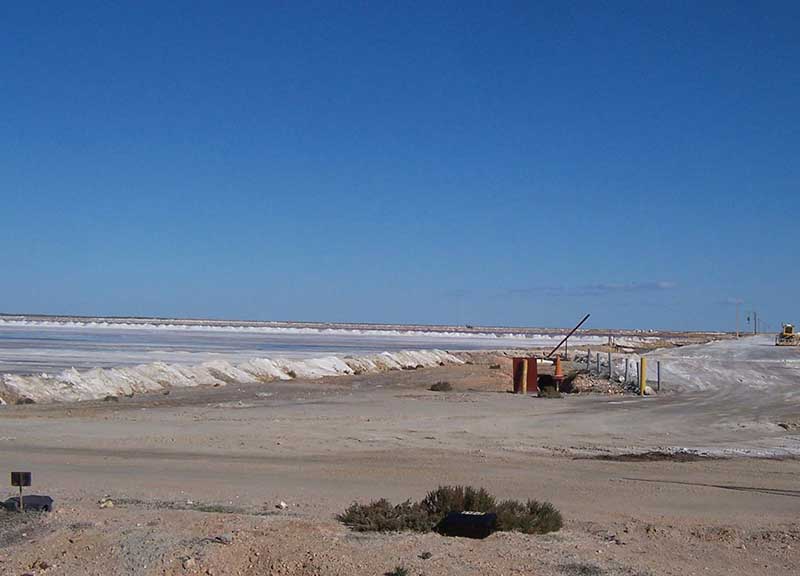
Cheetham Salt Works, Price
Like so many Yorke Peninsula towns, Price has a character of its own. Located just seven kilometres south of Port Clinton, it's a small settlement with substantial mangrove forest and birdlife. The mangroves and samphire tidal flats are crossed by a 1.5 kilometre causeway and the Price creek system, is popular with fishers. It's the ideal sheltered location for small fishing boats. Price is a location for one of Yorke Peninsula’s key mining industries, salt. Cheetham Salt uses a solar process for harvesting salt, and the huge salt pans can be seen alongside the township and as you cross the causeway to Wills Creek. Cheetham Salt provides Saxa table salt and pool salt, and was once the largest salt refinery in the Southern Hemisphere producing over 1000 tonnes per week.
"Walk The Yorke" is a 28 km walking trail that links Port Clinton to Ardrossan, passing through Price 7.8 km from Port Clinton. It can therefore be walked in two sections, both starting or finishing in Price.
Clinton (also known as Port Clinton) overlooks the north west head of Gulf St Vincent about 101 kilometres west of the state capital of Adelaide. Clinton was an important and busy port in the 1860s and 70s, being a transfer point for goods and passengers travelling between Port Adelaide and the copper mines at Wallaroo and Moonta. That was despite the shallowness of the beach, which closed the port to larger vessels during low tide. Clinton began a gradual decline after 1878 when the railway between Wallaroo and Adelaide was completed. The jetty was dismantled in 1916.
Port Clinton jetty site
Today, the town of some 300 residents is seen as "the Gateway to the Eastern Yorke Peninsula". Having a boat ramp, Clinton is popular for trailer boating. It has a beach for children, along with recreational fishing and crabbing areas. Raking for blue swimmer crabs is done on the extensive mud flats at low tide. As a result, after the 1950s the township attracted the construction of beach and holiday houses. The rural land surrounding Clinton is primarily used for dry grain farming of wheat and barley, with some sheep grazing.
Port Broughton is situated on a sheltered inlet at the extreme northern end of the peninsula on the east coast of Spencer Gulf, close to the Southern Flinders Ranges, Clare Valley wineries and the Copper Coast. The town is named after the Broughton River (named by explorer Edward John Eyre after William Broughton), the mouth of which is about 40 kilometres north of the township. With a population of around 1,000, its close proximity to Adelaide (two hours' drive) makes it a popular tourist destination, with the number of people in town swelling to over 4,000 in the summer holidays.
Since its establishment, Port Broughton's economy has largely been driven by agriculture, in particular cereal crops. Commercial fishing is also an important part of the economy, with scalefish and Blue swimmer crabs accounting for much of the catch. As of 2010 Port Broughton supports a prawning fleet. Like many towns on the Yorke Peninsula, Port Broughton is now a tourist destination, with activities such as fishing, crabbing and a variety of watersports being popular. The town has a boat ramp for such activities. Short-term accommodation includes two caravan parks, a number of units and a motel. Nearby Fisherman Bay has many shacks belonging to holiday-makers, as well a boat ramp for small vessels.


Design by W3layouts